How to Read a METAR and TAF for the Part 107 Test
By Part 107 HQ · Updated
Weather is 5% of the FAA Remote Pilot knowledge test (PSI UAG bulletin, p. 4), and its knowledge elements include METARs and TAFs (ACS, p. 11). The testing supplement prints METARs in Figure 12 and TAFs in Figure 15, and FAA sample questions ask you to decode Figure 12 (FAA UAG sample questions).
A METAR reports the weather observed at an airport; a TAF forecasts it. Most briefing services show a plain-language decode next to the code, but pilots should still know how to decode it in case a source does not (Aviation Weather Handbook, FAA-H-8083-28B, p. 24-5). The examples below were built for this guide following that handbook (AWH); they are not real reports.
METAR and SPECI
- A METAR is the routine report, produced near the top of each hour (AWH, p. 24-6).
- A SPECI is an unscheduled report taken between hourly reports when set criteria are met, such as visibility falling below 3 miles or a ceiling changing through 3,000, 1,500, 1,000 or 500 feet. It contains all the elements of a METAR (AWH, p. 24-6).
A METAR, group by group
METAR KICT 081853Z AUTO 19012G22KT 160V220 5SM -RA BR BKN009 OVC015 17/15 A2995 RMK AO2
- METAR: type of report. A special report starts with SPECI (AWH, p. 24-8).
- KICT: the four-letter ICAO station identifier. In the contiguous U.S. it is K followed by the three-letter identifier (AWH, p. 24-8).
- 081853Z: the 8th day of the month at 1853 UTC. The Z means Zulu time, another name for UTC (AWH, p. 24-9).
- AUTO: a fully automated report with no human intervention. COR in its place marks a corrected report (AWH, p. 24-9).
- 19012G22KT: wind from 190° true at 12 knots, gusting to 22 knots. The direction is where the wind comes from, in tens of degrees relative to true north. VRB means variable at 6 knots or less, and 00000KT means calm (AWH, p. 24-10).
- 160V220: the direction varies between 160° and 220°, reported when it varies by 60° or more at speeds above 6 knots (AWH, p. 24-10).
- 5SM: visibility 5 statute miles. A fraction follows a space, as in 1 1/2SM, and M means “less than” at automated stations (AWH, p. 24-11).
- -RA BR: light rain and mist. A minus sign means light, no sign moderate, and a plus sign heavy; VC means between 5 and 10 statute miles from the station (AWH, pp. 24-12, 24-13). ASOS reports fog (FG) below 5/8 statute mile, and mist (BR) from 5/8 to less than 7 miles when the temperature–dew point spread is about 2 °C or less, otherwise haze (HZ) (AWH, p. 24-3).
- BKN009 OVC015: broken clouds at 900 feet and overcast at 1,500 feet, in hundreds of feet above the surface (AGL). FEW is 1/8 to 2/8 of the sky, SCT 3/8 to 4/8, BKN 5/8 to 7/8 and OVC 8/8. CLR from an automated station means no layers detected at or below 12,000 feet (AWH, pp. 24-15, 24-16).
- 17/15: temperature 17 °C, dew point 15 °C. An M marks a value below zero (AWH, p. 24-18).
- A2995: altimeter setting 29.95 inches of mercury (AWH, p. 24-18).
- RMK AO2: remarks. AO2 is an automated station with a precipitation discriminator; AO1 has none (AWH, p. 24-20).
Ceiling and visibility
- The ceiling is the lowest layer aloft reported as broken or overcast. If the sky is totally obscured, the vertical visibility (VV) is the ceiling (AWH, p. 24-16). In the example the ceiling is 900 feet AGL.
- Part 107 requires at least 3 statute miles of flight visibility from the control station, and at least 500 feet below and 2,000 feet horizontally from clouds (14 CFR 107.51). If that 900-foot layer were over your operating area, 500 feet below it would be 400 feet AGL.
- A METAR gives the surface visibility at the station (AWH, p. 24-11); § 107.51 refers to flight visibility as observed from your control station.
A TAF, group by group
A TAF is a forecast for the area within 5 statute miles of the center of an airport’s runway complex. It uses the same weather codes as a METAR, and NWS TAFs do not include temperature. Most cover 24 hours; some major airports get 30 hours (AWH, p. 27-6).
TAF KICT 081730Z 0818/0918 19012G22KT 5SM -RA BR BKN009 OVC015
TEMPO 0819/0821 2SM RA BR OVC006
FM082300 24010KT P6SM BKN030 PROB30 0903/0906 3SM TSRA BKN025CB
FM090600 31012KT P6SM SKC
- TAF: a routine forecast. TAF AMD is an amended forecast, TAF COR a corrected one (AWH, p. 27-7).
- 081730Z: issued on the 8th at 1730 UTC. Routine TAFs are issued 20 to 40 minutes before their valid period begins (AWH, p. 27-8).
- 0818/0918: valid from the 8th at 1800 UTC to the 9th at 1800 UTC. An end time of midnight UTC is written as 24 (AWH, p. 27-8).
- 19012G22KT 5SM -RA BR BKN009 OVC015: the initial forecast, decoded like the METAR.
- TEMPO 0819/0821 2SM RA BR OVC006: between 1900 and 2100 UTC on the 8th, temporary periods of 2 miles visibility in moderate rain and mist under an overcast ceiling at 600 feet. TEMPO conditions have a greater than 50 percent probability, last one hour or less each time, and in total cover less than half the period. Elements not listed, here the wind, stay as forecast (AWH, p. 27-16).
- FM082300 24010KT P6SM BKN030: from 2300 UTC on the 8th, a complete new forecast supersedes everything before it: wind 240° at 10 knots, visibility greater than 6 statute miles (P6SM), ceiling broken at 3,000 feet (AWH, pp. 27-10, 27-15).
- PROB30 0903/0906 3SM TSRA BKN025CB: a 30 percent chance, between 0300 and 0600 UTC on the 9th, of a thunderstorm with moderate rain, 3 miles visibility and a broken cumulonimbus layer at 2,500 feet (AWH, p. 27-17). CB is the only cloud type in a TAF, and it is added whenever thunderstorms are forecast (AWH, p. 27-14).
- FM090600 31012KT P6SM SKC: from 0600 UTC on the 9th, wind 310° at 12 knots, visibility greater than 6 miles, sky clear. TAFs use SKC, never CLR (AWH, p. 27-13).
The forecast ceiling is the lowest level at which cumulative cloud cover reaches 5/8 or more, so the initial period here forecasts a 900-foot ceiling (AWH, p. 27-14).
The supplement’s TAF figure also uses BECMG and PROB40. The AIM defines BECMG (“becoming”) as a change expected during the stated period and notes that NWS TAFs exclude BECMG groups (AIM 7-1-28); PROB40 may appear in U.S. military and international TAFs (AWH, p. 27-17).
Converting Zulu time
All METAR and TAF times are UTC (AWH, pp. 24-9, 27-8). The testing supplement’s time conversion table gives the hours to add to local time to get UTC (FAA-CT-8080-2H, Figure 27):
- Eastern: standard time add 5, daylight time add 4
- Central: standard time add 6, daylight time add 5
- Mountain: standard time add 7, daylight time add 6
- Pacific: standard time add 8, daylight time add 7
To convert UTC to local time, subtract instead. If the example station kept central daylight time, 081853Z would be 1353 local on the 8th, and FM090600 would be 0100 local on the 9th.
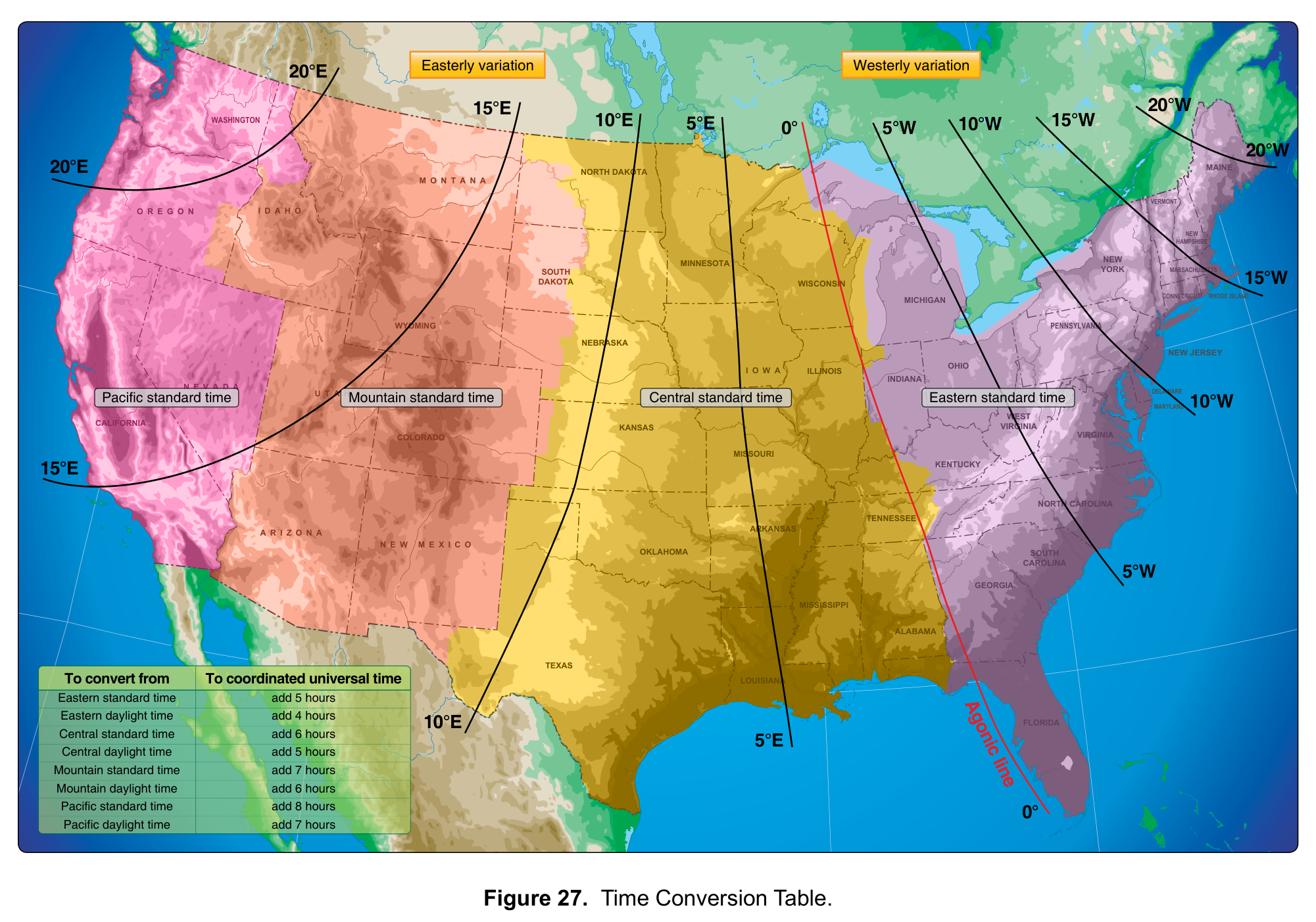
FAA-CT-8080-2H, Figure 27: Time Conversion Table. Select the image to enlarge it.
Where to get METARs and TAFs
- aviationweather.gov: the National Weather Service’s Aviation Weather Center. It is free, needs no registration and offers METARs and TAFs (AC 107-2A, para. B.3.1; AWH, p. 3-6).
- 1800wxbrief.com: Flight Service’s website, where remote pilots can create a free account for briefings. Flight Service’s telephone service is intended for manned aircraft pilots only (AC 107-2A, para. B.3).
- ASOS and AWOS: automated stations provide computer-generated voice observations by radio and telephone (AWH, pp. 24-2, 24-4), and sectional charts show their frequencies (FAA-CT-8080-2H, Legend 1). An ASOS broadcast can differ from the METAR because it uses one-minute observations (AWH, p. 24-3).
Practice decoding with the weather questions, and see how to read a sectional chart for the weather frequencies printed next to airports.