AGL vs MSL for Part 107: Convert Chart Altitudes
By Part 107 HQ · Updated
To convert AGL to MSL, add the ground elevation at the flight location: altitude MSL = ground elevation MSL + height AGL. To convert MSL to AGL, subtract: height AGL = altitude MSL − ground elevation MSL. Use the same location and units in both calculations. AGL is measured above ground; MSL is measured from mean sea level (FAA AIM, Pilot/Controller Glossary, “Altitude”).
This guide uses original learning examples, not FAA test questions. The numbers in the teaching diagram are hypothetical; FAA sources establish the altitude references and chart notation. For the full legend and other symbols, use the Part 107 sectional chart guide.
How do you convert AGL to MSL on a Part 107 chart question?
Add the height AGL to the ground elevation MSL directly beneath the aircraft. First identify the flight location, then check that the ground elevation and the requested height use feet. For example, over ground at 900 feet MSL, a drone at 200 feet AGL is at 1,100 feet MSL: 900 + 200 = 1,100. These references follow the FAA AIM glossary definition of altitude.
In reverse, a drone at 1,100 feet MSL over the same ground is 200 feet AGL: 1,100 − 900 = 200. If the question does not establish the ground elevation at the flight location, you cannot calculate an exact AGL height from an MSL altitude alone.
| What the question gives | Formula using values at the same location | Original example |
|---|---|---|
| Ground elevation MSL and height AGL | Altitude MSL = ground elevation MSL + height AGL | 900 + 200 = 1,100 feet MSL |
| Altitude MSL and ground elevation MSL | Height AGL = altitude MSL − ground elevation MSL | 1,100 − 900 = 200 feet AGL |
Write the reference beside the result. A bare answer of “1,100 feet” leaves out whether the question asks for height above ground or altitude above sea level.
What happens to AGL height when the ground elevation changes?
At a constant MSL altitude, the aircraft’s AGL height decreases over higher ground and increases over lower ground. AGL uses the ground at each location, so an elevation from the previous location cannot be carried into the next calculation (FAA AIM, Pilot/Controller Glossary, “Altitude”).
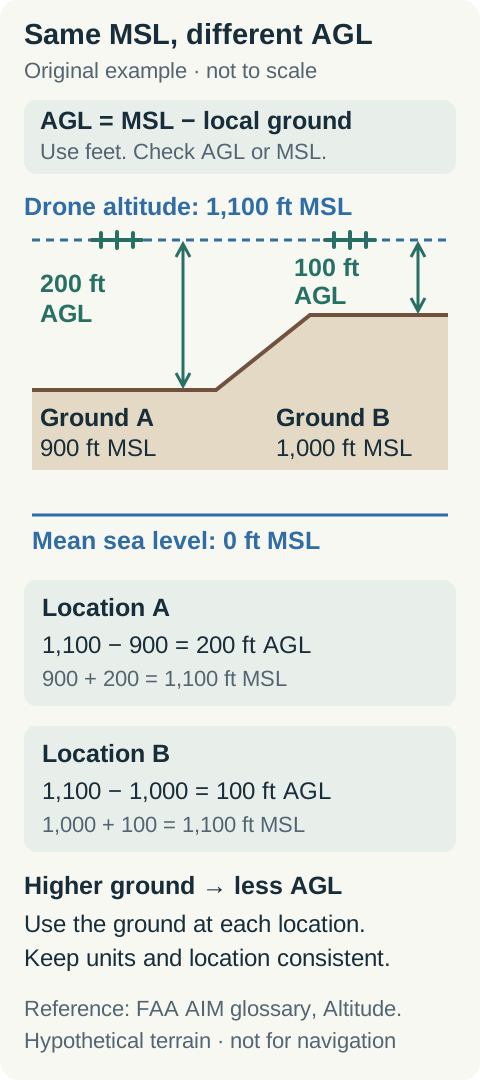
Original teaching diagram, not a navigation chart. Locations A and B and all elevations are hypothetical. Select the image to enlarge it.
In the diagram, a drone stays at 1,100 feet MSL. At location A, the ground is 900 feet MSL, giving 200 feet AGL. At location B, the ground is 1,000 feet MSL, giving 100 feet AGL. Keeping the same altitude above sea level does not keep the same height above terrain.
Which sectional chart altitudes use AGL and which use MSL?
Class B, C and D altitude numbers use MSL; the common Class E floors of 700 or 1,200 feet use AGL. Obstacle tops and airport elevations use MSL, while the height in parentheses beside an obstacle uses AGL. Read each number’s notation instead of assuming all chart altitudes have the same reference (FAA Chart Users’ Guide, pp. 11, 15–17).
| Chart information | Reference | How to interpret it |
|---|---|---|
| Class B or C sector ceiling and floor numbers | Feet MSL, in hundreds | A sector marked 40 over 20 has a 4,000-foot MSL ceiling and 2,000-foot MSL floor, before applying any additional symbols. |
| Class D ceiling number in a dashed box | Feet MSL, in hundreds | Check any minus sign: it means up to, but not including, the shown altitude. |
| Magenta shading for a Class E floor | 700 feet AGL | Convert to MSL using ground elevation at the selected location. |
| Class E floor of 1,200 feet where applicable | 1,200 feet AGL | Class E exists at 1,200 feet AGL unless designated otherwise; read boundaries and other floor labels. |
| Obstacle upper number | Feet MSL | Elevation of the obstacle’s top above mean sea level. |
| Obstacle number in parentheses | Feet AGL | Height of that obstacle above its base. |
| Airport elevation | Feet MSL | Highest point on the usable portion of its landing areas. |
| Maximum Elevation Figure (MEF) | Feet MSL, with the final two zeros omitted | Quadrant-wide maximum based on terrain or obstacles, with allowances and rounding; not local ground elevation. |
The table follows Chart Users’ Guide, pp. 11–17. Some Class E floors are labeled with other values, including MSL labels. A dashed magenta boundary depicts Class E beginning at the surface, not at 700 feet AGL (pp. 17, 27).
How do you convert a Class E floor of 700 feet AGL to MSL?
Add 700 feet to the local ground elevation MSL. Over ground at 900 feet MSL, that Class E floor is 1,600 feet MSL: 900 + 700 = 1,600. Over ground at 1,000 feet MSL, the same 700-foot AGL floor is 1,700 feet MSL. These are original calculations using the Class E floor reference defined in the FAA Chart Users’ Guide, p. 17.
Do not apply the omitted-zero rule for a Class B or C number to magenta shading. Shading that represents 700 feet AGL describes a height above the terrain; it does not establish a fixed 700-foot MSL altitude. A Class E floor above the surface also differs from an airport-designated Class E surface area. The Part 107 airspace guide explains those boundaries and § 107.41 authorization conditions.
Can you use the nearest airport elevation to convert AGL to MSL?
Not automatically: a nearby airport’s elevation does not establish the ground elevation beneath the drone. The FAA defines airport elevation as the highest point on the usable portion of the landing areas. Surrounding terrain may have a different elevation (FAA Chart Users’ Guide, p. 15).
Use the ground elevation that the question provides or establishes for its flight location. If a learning example explicitly says the ground there has the same elevation as the airport, that stated condition allows the substitution. Merely being near the airport does not.
For example, if an airport is 900 feet MSL but the question gives the drone’s ground location as 1,000 feet MSL, a drone at 1,100 feet MSL is 100 feet AGL, not 200 feet AGL. The location-specific value controls the subtraction. Chart contours show lines of equal elevation, but the FAA’s standard sectional contour spacing does not supply an exact value for every point between them (Chart Users’ Guide, p. 10).
Can an obstacle label or MEF give local ground elevation?
An obstacle’s two altitude numbers can give its own base elevation; MEF cannot give the ground elevation at an arbitrary flight location. An obstacle’s MSL top minus its parenthesized AGL height gives the MSL elevation of that obstacle’s base. That does not establish the terrain beneath a drone elsewhere (FAA Chart Users’ Guide, p. 11).
For the FAA legend’s 2049 (1149) obstacle, the base is 900 feet MSL: 2,049 − 1,149 = 900. The upper number is its top elevation, not its height above ground (FAA-CT-8080-2H, Legend 1). The sectional chart guide’s obstacle diagram shows those references.
An MEF represents a 30-minute latitude by 30-minute longitude quadrant’s highest terrain or vertical obstacle, with calculation allowances and upward rounding. For example, an MEF of 2,800 feet MSL does not say the ground beneath the drone is 2,800 feet MSL. Subtracting it from the drone’s altitude does not calculate local AGL height (FAA Chart Users’ Guide, pp. 12–13).
Does an AGL/MSL conversion establish permission to fly?
No. Converting altitude establishes a height reference; it does not establish airspace authorization or satisfy every Part 107 operating rule. Under § 107.51(b), the aircraft generally must remain at or below 400 feet AGL. The structure exception requires it to remain within a 400-foot radius of a structure and no higher than 400 feet above the structure’s immediate uppermost limit.
An MSL altitude below a Class B or C shelf says only that the drone is below that shelf. Identify the airspace at the actual location and altitude: Class B, C or D, or the lateral boundaries of a Class E surface area designated for an airport, require prior ATC authorization under § 107.41. For chart calculations and the other limits, continue with the sectional chart guide and Part 107 rules.
Free AGL/MSL practice with worked answers
These original checks practice adding local ground elevation to AGL, subtracting it from MSL, and recognizing an AGL airspace floor. All numbers are hypothetical. The formulas use the FAA AIM altitude definitions; the Class E reference comes from the Chart Users’ Guide, p. 17.
Ground at the drone's location is 760 feet MSL. The drone is 325 feet AGL. What is its MSL altitude?
1,085 feet MSL: 760 feet MSL + 325 feet AGL = 1,085 feet MSL. The 325-foot value is measured above that same ground, so the references can be combined.
A drone is at 1,850 feet MSL over ground at 1,530 feet MSL. What is its AGL height?
320 feet AGL: 1,850 − 1,530 = 320. A nearby airport’s elevation would not replace the given ground value at the drone’s location.
At location B in the diagram, ground is 1,000 feet MSL. If Class E begins at 700 feet AGL there, what is the floor in MSL?
1,700 feet MSL: 1,000 + 700 = 1,700. The floor uses AGL, so it follows the local ground reference. This calculation does not describe a Class E surface area or determine permission to fly.
Apply the units to real, dated FAA excerpts in the free sectional chart practice. For airport frequency questions, use the CTAF and UNICOM guide.