How to Read a Sectional Chart for the Part 107 Test
By Part 107 HQ · Updated
Read a sectional chart by finding the location, identifying the airspace boundary, and attaching a reference to each number. MSL means height above mean sea level; AGL means height above ground. An obstacle’s upper number is its top elevation in feet MSL, while the number in parentheses is its height in feet AGL. To compare an MSL altitude with a height above ground, subtract the ground elevation at the same location (AIM, Pilot/Controller Glossary, “Altitude”; Chart Users’ Guide, p. 11).
A sectional is the FAA’s 1:500,000-scale chart for visual navigation, updated every 56 days (FAA sectional chart catalog). One inch on it equals 6.86 nautical miles (PHAK, p. 16-2). The examples below separate airspace limits, airport data and obstacle heights using the FAA legend, a dated chart excerpt and original teaching diagrams.
Questions that refer to a figure use the testing supplement, FAA-CT-8080-2H, which the test center supplies, and they often name a numbered area, such as “Refer to FAA-CT-8080-2H, Figure 26, area 4” (FAA UAG sample questions; PSI UAG bulletin, p. 5). The FAA also embeds images directly in some unmanned aircraft test questions (FAA ATCA, September 2026, p. 5), and from October 26, 2026, the test will include image-based questions not found in the supplement, with up-to-date images from the latest charts, including sectional charts (p. 6).
This guide works through the symbols and calculations behind those questions. For the dates and exam format, see Part 107 test changes in 2026. For a set of original questions using dated FAA excerpts, open the free sectional chart practice.
Start with the legend
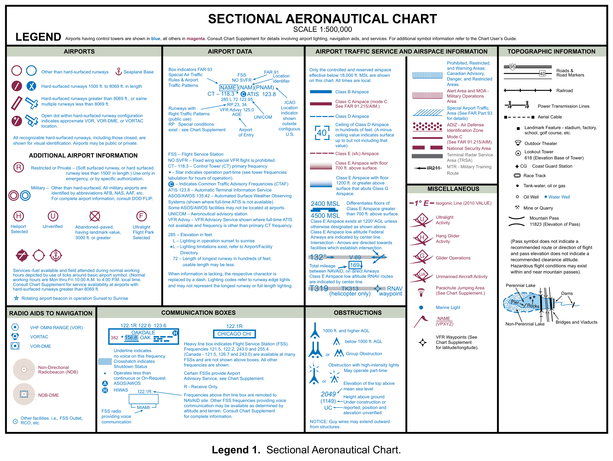
FAA-CT-8080-2H, Legend 1: Sectional Aeronautical Chart. Select the image to enlarge it.
Three notes on the legend set the basics (FAA-CT-8080-2H, Legend 1):
- Airports with control towers are shown in blue; all others are magenta.
- Only controlled and reserved airspace effective below 18,000 feet MSL is shown.
- All times on the chart are local.
Class B, C and D floor and ceiling figures, obstacle tops and maximum elevation figures are in feet above mean sea level (MSL) (Chart Users’ Guide, pp. 11, 12, 16, 27), while the Part 107 altitude limit is in feet above ground level (AGL) (14 CFR 107.51).
Airspace boundaries and altitudes
- Class B: each sector’s MSL ceiling and floor are printed in solid blue figures with the last two zeros omitted, so 100 means 10,000 feet. A floor preceded by a plus sign extends “upward from above” that altitude: at and below it you are outside Class B (Chart Users’ Guide, p. 16).
- Class C: the same scheme in solid magenta figures. A ceiling of “T” means up to, but not including, the floor of the overlying Class B (Chart Users’ Guide, p. 16).
- Class D: a blue dashed line. The ceiling is given in hundreds of feet MSL; a minus sign in front of it means from the surface up to, but not including, that altitude (Chart Users’ Guide, pp. 16, 27).
- Class E surface area: a magenta dashed line (Chart Users’ Guide, p. 17).
- Class E with a floor above the surface: a magenta vignette marks a 700-foot AGL floor; a blue vignette marks a floor of 1,200 feet or more where it borders Class G; other floors above 700 feet are labeled, as in “2400 MSL”. Class E exists at 1,200 feet AGL unless otherwise designated (Chart Users’ Guide, p. 17; FAA-CT-8080-2H, Legend 1).
- Class G: airspace not designated as Class A, B, C, D or E, from the surface up to the overlying Class E (AIM 3-3-1; Remote Pilot Study Guide, p. 6).
- Class A starts at 18,000 feet MSL and is not depicted on visual charts (Chart Users’ Guide, p. 16).
Treat a dashed outline and a shaded edge as different clues. A magenta dashed outline depicts Class E beginning at the surface; magenta shading depicts a 700-foot AGL floor. A blue vignette can depict a 1,200-foot or higher floor where Class E borders Class G. Check any labeled floor and which side of the boundary contains the location (Chart Users’ Guide, pp. 17, 27). The Class E diagram and worked examples show the vertical difference.
Airport data and frequencies
The legend’s sample airport data reads as follows (FAA-CT-8080-2H, Legend 1):
- CT – 118.3: the control tower’s primary frequency. A star means the tower operates part-time.
- A C in a solid circle after a frequency marks the Common Traffic Advisory Frequency (CTAF).
- ATIS 123.8: the automatic terminal information service. ASOS/AWOS 135.42: automated surface weather observing systems, shown where full-time ATIS is not available.
- 285 L 72 122.95: elevation 285 feet; runway lighting in operation sunset to sunrise; longest runway 7,200 feet, though usable length may be less; UNICOM on 122.95.
- A dash replaces any item for which information is lacking.
Where a tower is part-time, its Class D surface area may revert to Class E or Class G while the tower is closed; the Chart Supplement says which (AIM 3-2-5). An FAA sample image question asks which frequency to use as the CTAF when the tower is not in operation (FAA ATCA, September 2026, p. 10).
Small UAS operators are encouraged to monitor the CTAF on or near an airport, but should not contact ATC by radio or telephone for airspace access (AIM 11-8-2).
Worked example: separate airport elevation from runway length
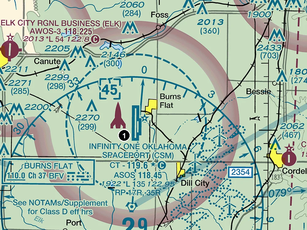
FAA Dallas-Ft Worth Sectional, September 3, 2026 edition, around INFINITY ONE OKLAHOMA SPACEPORT (CSM). The numbered marker was added for practice. Select the image to enlarge it; source: FAA VFR raster charts.
Read the CSM line 1922 *L 135 122.95 one item at a time. 1922 is the airport elevation, in feet MSL. The FAA defines that elevation as the highest point on the usable portion of the landing areas, so it is not a ground-elevation value for every nearby location (Chart Users’ Guide, p. 15). 135 is the longest runway length in hundreds of feet: 135 × 100 = 13,500 feet. 122.95 is UNICOM, while the circled C beside 119.6 identifies the CTAF. These are different fields, even though they sit in one data block (FAA-CT-8080-2H, Legend 1).
For a question about traffic monitoring, look for the circled C. For an elevation question, use 1922. For a drone operating away from the airport, establish the ground elevation at the actual flight location before converting AGL to MSL. The CTAF and UNICOM guide explains the frequency labels, and the airport traffic pattern guide explains the nearby RP notation.
Obstacles: MSL on top, AGL in parentheses
Sectionals typically show man-made obstacles more than 200 feet AGL, or more than 299 feet AGL inside the yellow tint of populated areas (Chart Users’ Guide, p. 11).
- The upper number is the elevation of the top in feet MSL; the number in parentheses below it is the height above ground (Chart Users’ Guide, p. 11). In the legend’s example, 2049 (1149), the top is at 2,049 feet MSL and the structure is 1,149 feet tall, so the ground at its base is 900 feet MSL.
- Different symbols mark obstacles below 1,000 feet AGL and those 1,000 feet AGL and higher. In dense areas a group obstacle symbol shows only the highest obstacle (Chart Users’ Guide, p. 11).
- UC means under construction or reported, with position and elevation unverified. Guy wires may extend outward from structures (FAA-CT-8080-2H, Legend 1).
Part 107 limits you to 400 feet AGL unless you stay within a 400-foot radius of a structure and no higher than 400 feet above its immediate uppermost limit (14 CFR 107.51), so convert chart figures to AGL before comparing.
Worked example: convert AGL and MSL without changing the reference
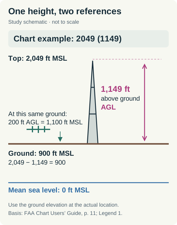
Original teaching diagram based on the obstacle notation in FAA-CT-8080-2H, Legend 1. The drone altitude is a hypothetical example; the diagram is not a navigation chart.
Start with the legend’s 2049 (1149) obstacle. Its top is 2,049 feet MSL and its height is 1,149 feet AGL. Subtract to find the base elevation: 2,049 − 1,149 = 900 feet MSL (Chart Users’ Guide, p. 11).
Now assume the ground directly beneath a drone is also 900 feet MSL. A flight at 200 feet AGL is at 900 + 200 = 1,100 feet MSL. In reverse, 1,100 − 900 = 200 feet AGL. These calculations use the same ground reference. The obstacle’s base or a nearby airport’s elevation does not establish the ground elevation at a different location.
Worked example: read a shelf floor before deciding the airspace
Suppose a Class C sector is labeled 40 over 20 in magenta, with no additional symbols: its ceiling is 4,000 feet MSL and its floor is 2,000 feet MSL. If the ground at the proposed flight location is 800 feet MSL, a drone at 300 feet AGL would be at 1,100 feet MSL, below that Class C shelf. The numbers are hypothetical; the units and omitted-zero convention come from the Chart Users’ Guide, p. 16.
That calculation answers whether the drone is in the Class C shelf. Next identify the airspace beneath it: another airport’s Class D or airport-designated Class E surface area could still require authorization under § 107.41. A shelf’s floor is not the Part 107 altitude limit.
Maximum elevation figures
The Maximum Elevation Figure (MEF) is the highest elevation within a quadrant, including terrain and obstacles such as towers and trees. On sectionals a quadrant is bounded by the ticked lines dividing each 30 minutes of latitude and each 30 minutes of longitude. MEFs are rounded up to the nearest 100 feet, and the last two digits are not shown (Chart Users’ Guide, p. 12), so an MEF of 2,800 feet MSL appears as 28. The figures are not verified by field surveys (Chart Users’ Guide, p. 13).
Latitude and longitude
Parallels of latitude measure degrees north or south of the equator; meridians of longitude measure degrees east or west of the Prime Meridian. The contiguous United States lies between 25° and 49° N and between 67° and 125° W, so on U.S. charts latitude grows toward the north and longitude toward the west: Washington, D.C. is about 39° N, 77° W, and Chicago about 42° N, 88° W (PHAK, p. 16-3).
FAA sample questions give positions in degrees and minutes, such as 47°40’ N and 101°26’ W, or in decimal degrees, such as 46.9N and 98.6W (FAA UAG sample questions).
Special use and other airspace
- Prohibited, restricted, warning and alert areas are charted as P, R, W or A followed by a number; military operations areas (MOAs) are named, not numbered; controlled firing areas are not charted (Remote Pilot Study Guide, pp. 7–9).
- Flying in a prohibited or restricted area requires permission from the using or controlling agency (14 CFR 107.45).
- Military training routes (IR or VR) with four-digit numbers have no segment above 1,500 feet AGL; those with three or fewer digits have one or more segments above it (Chart Users’ Guide, p. 18).
- Symbols for unmanned aircraft, parachute jumping, glider, hang glider and ultralight activity mark miscellaneous activity areas; pilots are expected to check NOTAMs before flight (Chart Users’ Guide, pp. 17, 31).
- Only temporary flight restrictions (TFRs) relating to national security are charted (Chart Users’ Guide, p. 18), and the remote pilot must check NOTAMs before each flight (AC 107-2A, para. 5.10.3).
A step-by-step method for chart questions
- Pin down the question: airspace class, altitude, frequency, ATC authorization or a hazard?
- Find the spot. Use the area number, the airport name or the coordinates.
- Identify every boundary around it with the legend: lines, vignettes and special use borders.
- Read each number with its reference. Airspace figures (in hundreds of feet) and obstacle tops are MSL; heights in parentheses are AGL.
- Convert MSL to AGL by subtracting the ground elevation at that spot before comparing with the 400-foot limit.
- Apply the rule. Operations in Class B, C or D, or within the lateral boundaries of a Class E surface area designated for an airport, need prior ATC authorization under § 107.41, requested through LAANC or DroneZone (AIM 11-1-2); prohibited and restricted areas need the agency’s permission.
- Eliminate traps. Rule out choices that swap MSL and AGL, or that treat a Class E floor of 700 or 1,200 feet AGL as a surface area (AIM 3-2-6).
Free sectional chart self-check
These are original learning checks, not FAA test questions. Answer first, then open each explanation.
An obstacle is labeled 2049 (1149). What is its height above ground?
1,149 feet AGL. The parenthesized number gives height above the obstacle’s base; 2,049 is the top elevation in feet MSL. See Chart Users’ Guide, p. 11.
The ground beneath a drone is 900 feet MSL. What is 1,100 feet MSL in AGL?
200 feet AGL: 1,100 − 900 = 200. Compare that height with the limit in § 107.51(b); the conversion alone does not establish permission to fly.
In the CSM excerpt, which frequency is marked as CTAF: 119.6, 118.45 or 122.95?
119.6 MHz, marked with a circled C. The excerpt labels 118.45 as ASOS; 122.95 occupies the UNICOM field. The symbols are explained in FAA-CT-8080-2H, Legend 1.
Continue with the free sectional chart questions, then use the airspace questions to connect the symbols to authorization rules. The Part 107 airspace guide, CTAF and UNICOM guide and traffic pattern guide cover the next steps.
For a narrated walkthrough of these examples, watch Part 107 Sectional Charts: AGL vs MSL, Class E & CTAF Explained.