Question Bank
For pilots who already have a study routine.
$19one-time
- All 765 practice questions
- Full explanations & official sources
- All 64 current-chart questions
- Topic drills & missed-question review
Airspace questions ask where you may fly and what you need first. These Part 107 practice questions train you to recognize Class B, C, D and E airspace on a sectional chart, to know when ATC authorization is required under § 107.41, to read airport data, obstacle heights and coordinates, and to understand special use airspace, temporary flight restrictions and NOTAMs.
20% of the test. That is the FAA weighting for this area since September 29, 2025 — about 12 of the 60 scored questions.
Chart questions here use the figures from the FAA testing supplement. Our separate sectional chart questions use excerpts from the current FAA charts — the kind of image the FAA adds to the test from October 26, 2026.
36 of the 221 questions in this area are free to read here. Try to answer before you open the explanation.
Which classes of airspace make up controlled airspace?
Answer: B. Class A, B, C, D, and E airspace.
AIM 3-2-1 defines controlled airspace as a generic term covering Class A, Class B, Class C, Class D, and Class E airspace, within which ATC service is provided to IFR and VFR flights according to the airspace classification. Listing only Class B, C, and D leaves out Class A and Class E, which are also controlled, even though the Remote Pilot Study Guide notes that in most cases a remote pilot will not need ATC authorization in Class E. Class G is never controlled: AIM 3-3-1 describes it as the uncontrolled airspace not designated as Class A, B, C, D, or E. Memory tip: A through E are controlled; G stands alone.
Source
A generic term that covers the different classification of airspace (Class A, Class B, Class C, Class D, and Class E airspace) and defined dimensions within which air traffic control service is provided
Class G airspace (uncontrolled) is that portion of airspace that has not been designated as Class A, Class B, Class C, Class D, or Class E airspace.
Unless otherwise authorized, how must aircraft be operated in Class A airspace?
Answer: B. Under instrument flight rules (IFR).
AIM 3-2-2 states that, unless otherwise authorized, all persons must operate their aircraft under IFR in Class A airspace, and PHAK p. 15-9 adds that the operation must be conducted under an ATC clearance received before entering the airspace. The AIM's basic VFR weather minimums table lists Class A as 'not applicable,' because VFR flight is not conducted there. Remaining clear of clouds is the VFR cloud clearance for Class B, and 3 statute miles is the VFR visibility for Class B, C, D, and Class E below 10,000 feet MSL, so neither describes Class A.
Source
Unless otherwise authorized, all persons must operate their aircraft under IFR.
Pilots operating an aircraft in Class A airspace must conduct that operation under IFR and only under an ATC clearance received prior to entering the airspace.
Class B airspace generally extends from the surface up to what altitude?
Answer: C. 10,000 feet MSL around the nation's busiest airports.
AIM 3-2-3 and the Remote Pilot Study Guide (p. 5) describe Class B airspace as generally extending from the surface to 10,000 feet MSL surrounding the nation's busiest airports. Surface to 4,000 feet above the airport elevation is the general shape of Class C airspace, and surface to 2,500 feet above the airport elevation describes Class D airspace. The Study Guide also states that a remote pilot must receive authorization from ATC before operating in Class B airspace. Memory tip: B, C, and D step down from 10,000 feet MSL to 4,000 and then 2,500 feet above the airport.
Source
Generally, that airspace from the surface to 10,000 feet MSL surrounding the nation's busiest airports in terms of IFR operations or passenger enplanements.
A remote pilot must receive authorization from ATC before operating in the Class B airspace.
Class C airspace generally extends from the surface up to what height?
Answer: B. 4,000 feet above the airport elevation, charted in MSL.
AIM 3-2-4 and the Remote Pilot Study Guide (p. 6) describe Class C airspace as generally extending from the surface to 4,000 feet above the airport elevation, charted in MSL, around airports that have an operational control tower, are serviced by a radar approach control, and have a certain number of IFR operations or passenger enplanements. Surface to 2,500 feet above the airport elevation is the general shape of Class D airspace, and surface to 10,000 feet MSL describes Class B. The Study Guide adds that a remote pilot must receive authorization before operating in Class C airspace.
Source
Generally, that airspace from the surface to 4,000 feet above the airport elevation (charted in MSL) surrounding those airports that have an operational control tower, are serviced by a radar approach control
A remote pilot must receive authorization before operating in Class C airspace.
Within the inner circle of a Class C area, the sectional chart shows the magenta figures 41 above SFC. What vertical limits do these figures describe?
Answer: B. From the surface up to 4,100 feet MSL.
The Chart User's Guide (p. 16) states that Class C ceiling and floor altitudes are shown in solid magenta figures in MSL with the last two zeros eliminated. A ceiling of 41 is therefore 4,100 feet MSL, and SFC means the floor is the surface. Reading the ceiling as AGL is a common mistake: AIM 3-2-4 explains that the ceiling is generally 4,000 feet above the airport elevation but is charted in MSL. Reading 41 as 410 feet drops only one zero instead of two. Because this inner circle starts at the surface, a remote pilot flying anywhere inside it needs § 107.41 authorization.
Source
Class C Airspace is shown on Sectionals and TACs. The MSL ceiling and floor altitudes of each sector are shown in solid magenta figures with the last two zeros eliminated.
Generally, that airspace from the surface to 4,000 feet above the airport elevation (charted in MSL) surrounding those airports that have an operational control tower, are serviced by a radar approach control
A remote pilot plans to fly at 250 feet AGL about 15 NM from a Class C primary airport, outside the charted Class C boundary, in Class G airspace. A colleague warns that the Class C 'outer area' extends 20 NM. Does the outer area require ATC authorization?
Answer: B. No; the outer area is not charted and excludes the Class C airspace itself.
AIM 3-2-4 describes a procedural outer area, normally 20 NM from the primary Class C airport, whose limits exclude the Class C airspace itself and which is not charted. Section 107.41 requires prior authorization only for Class B, C, or D airspace or the surface area of Class E designated for an airport. The planned site is outside the charted Class C and in Class G, and the Remote Pilot Study Guide states that a remote pilot will not need ATC authorization to operate in Class G airspace. Nothing in the AIM turns the outer area into a Class E surface area; it is a procedural area where Class C services are offered to participating aircraft.
Source
Class C airspace areas have a procedural Outer Area. Normally this area is 20 NM from the primary Class C airspace airport.
excluding the Class C airspace itself, and other airspace as appropriate. (This outer area is not charted.)
No person may operate a small unmanned aircraft in Class B, Class C, or Class D airspace or within the lateral boundaries of the surface area of Class E airspace designated for an airport unless that person has prior authorization
Next to a Class D airport, the sectional chart shows the Class D ceiling as a minus sign followed by 32. What vertical limits does this indicate?
Answer: B. From the surface up to, but not including, 3,200 feet MSL.
The Chart User's Guide (pp. 16 and 27) explains that Class D ceilings are shown in hundreds of feet MSL and that a minus in front of the figure indicates 'from surface to, but not including' that value. A figure of minus 32 therefore means the Class D extends from the surface up to, but not including, 3,200 feet MSL. The value is MSL, not AGL, and only the last two zeros are omitted, so it does not mean 320 feet. Because the Class D begins at the surface, any small UAS operation within its lateral limits needs prior authorization under § 107.41.
Source
A minus in front of the figure is used to indicate "from surface to, but not including..."
Altitude in hundreds of feet MSL (A minus in front of the figure is used to indicate "from surface to but not including...")
What class of airspace lies above FL 600?
Answer: C. Class E airspace.
PHAK p. 15-3 and AIM 3-2-6 state that all airspace above FL 600 is Class E airspace. Class A extends from 18,000 feet MSL up to and including FL 600, so it ends at FL 600 rather than continuing above it. Class G is the uncontrolled airspace that has not been designated as Class A, B, C, D, or E, and the airspace above FL 600 has been designated Class E. Memory tip: Class E sits both below Class A, typically up to but not including 18,000 feet MSL, and above it, beyond FL 600.
Source
Class E airspace typically extends up to, but not including, 18,000 feet MSL (the lower limit of Class A airspace). All airspace above FL 600 is Class E airspace.
The airspace above FL 600 is Class E airspace.
In the evening, the control tower at a part-time towered airport closes. The airport is also surrounded by a magenta vignette. What happens to the Class E airspace beginning at 700 feet AGL when the tower closes?
Answer: B. It remains in effect, because transition areas are continuous.
AIM 3-2-6 states that the 700-foot and 1,200-foot AGL Class E transition areas remain in effect continuously, regardless of airport operating hours or surface area status. Only the part-time surface area changes when the tower closes, reverting to a Class E surface area or to Class G as stated in the Chart Supplement (AIM 3-2-5). The transition area neither reverts to Class G nor changes its floor while the tower is closed. The AIM also cautions not to confuse the 700-foot and 1,200-foot transition areas with surface areas or surface area extensions.
Source
The 700-foot/1200-foot AGL Class E airspace transition areas remain in effect continuously, regardless of airport operating hours or surface area status.
Do not confuse the 700-foot and 1200-foot Class E transition areas with surface areas or surface area extensions.
A remote pilot is flying in Class G airspace when a helicopter passes nearby at low altitude. Which statement about air traffic control in this airspace is correct?
Answer: B. ATC has no authority or responsibility to control air traffic in Class G.
PHAK p. 15-3 states that in Class G airspace ATC has no authority or responsibility to control air traffic, although VFR minimums still apply to manned pilots. No separation service exists there, so avoiding the helicopter is the remote pilot's job: § 107.37(a) requires the small unmanned aircraft to yield the right of way to all aircraft, and AIM 11-8-3 reminds operators that manned aircraft, including helicopters, may fly below 400 feet AGL. ATC approval is not needed either; the Remote Pilot Study Guide states that a remote pilot will not need ATC authorization to operate in Class G airspace.
Source
Although ATC has no authority or responsibility to control air traffic, pilots should remember there are visual flight rules (VFR) minimums that apply to Class G airspace.
Each small unmanned aircraft must yield the right of way to all aircraft, airborne vehicles, and launch and reentry vehicles.
A remote pilot will not need ATC authorization to operate in Class G airspace.
Under § 107.41, where must a remote pilot have prior authorization from ATC before operating a small unmanned aircraft?
Answer: B. In Class B, C, or D airspace, or the Class E surface area designated for an airport.
Section 107.41 prohibits operating a small unmanned aircraft in Class B, Class C, or Class D airspace or within the lateral boundaries of the surface area of Class E airspace designated for an airport unless the person has prior authorization from ATC. It does not cover all Class E airspace: the Remote Pilot Study Guide notes that in most cases a remote pilot will not need ATC authorization in Class E, such as a transition area beginning at 700 or 1,200 feet AGL. Class D is expressly included, and the Study Guide confirms that a remote pilot must receive ATC authorization before operating in Class D airspace.
Source
No person may operate a small unmanned aircraft in Class B, Class C, or Class D airspace or within the lateral boundaries of the surface area of Class E airspace designated for an airport unless that person has prior authorization
In most cases, a remote pilot will not need ATC authorization to operate in Class E airspace.
A remote pilot must receive ATC authorization before operating in Class D airspace.
A remote pilot inspects a 900-foot antenna in an area where Class E begins at 700 feet AGL (magenta vignette), with no surface area nearby. The drone stays within 400 feet of the antenna and climbs to 850 feet AGL. Is ATC authorization required?
Answer: B. No; § 107.41 covers Class E only within a surface area designated for an airport.
At 850 feet AGL the drone is in the Class E transition area that begins at 700 feet AGL. Section 107.41 requires authorization only in Class B, C, or D airspace or within the lateral boundaries of the surface area of Class E designated for an airport, and AIM 3-2-6 warns not to confuse transition areas with surface areas. The FAA FAQ notes that the § 107.51 structure provision applies to operations in Class G or Class E airspace. Under § 107.51(b), flight above 400 feet AGL is allowed within a 400-foot radius of a structure and no higher than 400 feet above its top, here 1,300 feet AGL.
Source
No person may operate a small unmanned aircraft in Class B, Class C, or Class D airspace or within the lateral boundaries of the surface area of Class E airspace designated for an airport unless that person has prior authorization
Do not confuse the 700-foot and 1200-foot Class E transition areas with surface areas or surface area extensions.
This applies to UAS or drones operating in Class G or Class E airspace. In other airspace classifications, like Class D airspace, an authorization per 107.41 is required.
A towered airport's Chart Supplement entry reads 'other times CLASS E.' A remote pilot plans to fly in the former Class D surface area during daylight after the tower has closed. Is ATC authorization still required?
Answer: C. Yes; the surface area becomes a Class E surface area, which still requires authorization.
AIM 3-2-6 explains that a Class E surface area may be designated to accommodate part-time operations at a Class C or Class D location, such as when the control tower is not in operation, and that the Chart Supplement airspace entry states 'other times Class E' or 'other times Class G.' Here it says Class E, so the surface area does not become Class G. Section 107.41 requires prior authorization within the lateral boundaries of the surface area of Class E airspace designated for an airport, so the requirement continues after the tower closes. Only an 'other times Class G' entry would leave Class G at the surface.
Source
A Class E surface area may also be designated to accommodate part-time operations at a Class C or Class D airspace location (for example, those periods when the control tower is not in operation).
In such cases, the "Airspace" entry for the airport in the Chart Supplement will state "other times Class E" or "other times Class G."
No person may operate a small unmanned aircraft in Class B, Class C, or Class D airspace or within the lateral boundaries of the surface area of Class E airspace designated for an airport unless that person has prior authorization
A remote pilot plans to fly at 300 feet AGL about 22 NM from a Class B primary airport. The site is inside the solid magenta 30 NM Mode C ring but outside the lateral limits of the Class B, in Class G airspace. Is ATC authorization required?
Answer: B. No; the Mode C ring is not one of the areas listed in § 107.41.
The Chart User's Guide (p. 17) explains that the solid magenta 30 NM line marks Mode C required airspace from the surface to 10,000 feet MSL, an equipment requirement area that AIM 3-2-3 calls the Mode C veil. Section 107.41 requires prior authorization only in Class B, C, or D airspace or the Class E surface area designated for an airport. This site is outside the Class B lateral limits and in Class G, and the Remote Pilot Study Guide states that a remote pilot will not need ATC authorization to operate in Class G airspace. The ring is not a surface area of any class.
Source
Mode C Required Airspace (from the surface to 10,000' MSL) within a 30 NM radius of the primary airport(s) for which a Class B is designated, is depicted by a solid magenta line.
No person may operate a small unmanned aircraft in Class B, Class C, or Class D airspace or within the lateral boundaries of the surface area of Class E airspace designated for an airport unless that person has prior authorization
A remote pilot will not need ATC authorization to operate in Class G airspace.
A sectional chart shows an area labeled P-40. What type of airspace is this?
Answer: B. A prohibited area, within which the flight of aircraft is prohibited.
The study guide and PHAK explain that a prohibited area is charted as a "P" followed by a number, citing P-40 at Camp David; the National Mall in Washington, D.C., is another example. AIM 3-4-2 says prohibited areas contain airspace of defined dimensions within which the flight of aircraft is prohibited, established for security or other reasons associated with the national welfare. Parachute jump areas do not use P-numbers; frequently used sites appear on sectionals with a parachute jumping area symbol and frequency, and the Chart Supplement tabulates them. Landowners cannot close airspace: AIM 11-4-6h explains that a "No Drone Zone" sign applies only to the ground, not the airspace. Under § 107.45, flying in a prohibited area requires permission from the using or controlling agency.
Source
The area is charted as a "P" followed by a number (e.g., P-40). Examples of prohibited areas include Camp David and the National Mall in Washington, D.C., where the White House and the Congressional buildings are located.
Prohibited areas contain airspace of defined dimensions identified by an area on the surface of the earth within which the flight of aircraft is prohibited.
A remote pilot notices a charted military operations area (MOA) near a planned job. For what purpose are MOAs established?
Answer: B. To separate certain military training activities from IFR traffic.
AIM 3-4-5a says MOAs consist of airspace of defined vertical and lateral limits established for the purpose of separating certain military training activities from IFR traffic. Examples of those activities include air combat tactics, air intercepts, aerobatics, formation training, and low-altitude tactics (AIM 3-4-5b). MOAs do not prohibit civil flight: they are nonregulatory special use airspace (AIM 3-4-1c), and AIM 3-4-5c tells VFR pilots to exercise extreme caution in an active MOA rather than to stay out. Defined routes for low-altitude, high-speed military training are military training routes (AIM 3-5-2), not MOAs. MOAs are named rather than numbered on charts, for example the "Camden Ridge MOA."
Source
MOAs consist of airspace of defined vertical and lateral limits established for the purpose of separating certain military training activities from IFR traffic.
Examples of activities conducted in MOAs include, but are not limited to: air combat tactics, air intercepts, aerobatics, formation training, and low-altitude tactics.
A remote pilot's planned flight area lies inside an area charted as A-560. What should the pilot expect there?
Answer: B. A high volume of pilot training or an unusual type of aerial activity.
Alert areas are depicted on aeronautical charts with an "A" followed by a number to inform nonparticipating pilots of areas that may contain a high volume of pilot training or an unusual type of aerial activity (study guide p. 9; AIM 3-4-6). Artillery firing and guided missiles describe restricted areas, which carry an "R" designation and require permission under § 107.45. Airport advisory service is a service an FSS on the airport provides (AIM 3-5-1), not an A-numbered area. Alert areas are nonregulatory, so the permission rule of § 107.45 does not apply, but the AIM says pilots should be particularly alert there. The Chart Users' Guide adds that alert areas do not extend into Class A, B, C, and D airspace or Class E airport surface areas.
Source
Alert areas are depicted on aeronautical charts with an "A" followed by a number (e.g., A-211) to inform nonparticipating pilots of areas that may contain a high volume of pilot training or an unusual type of aerial activity.
Alert Areas do not extend into Class A, B, C and D airspace, or Class E airport surface areas.
Three TFRs issued under 14 CFR 91.137 are in effect in one region: one over a toxic gas leak, one over a forest fire being fought by aircraft releasing fire retardant, and one to prevent unsafe congestion of sightseeing aircraft above an incident of high public interest. In which of them may ATC authorize an operation under its own authority?
Answer: A. Only the firefighting and sightseeing-congestion TFRs.
AIM 3-5-3h states that ATC may authorize operations in a TFR area under its own authority only when the restrictions are established under 14 CFR 91.137(a)(2) and (a)(3). AIM 3-5-3e lists forest fires fought by releasing fire retardants from aircraft among the situations for (a)(2) restrictions, whose purpose is a safe environment for disaster relief aircraft, and preventing sightseeing congestion above an incident of high public interest is the (a)(3) purpose. The same paragraph lists toxic gas leaks among (a)(1) situations; under § 91.137(b), only aircraft participating in hazard relief under the direction of the official in charge of on-scene emergency response may operate there, so ATC cannot approve entry on its own. That rules out both other answers. Even where ATC can authorize flights, it ensures they do not hamper the activities or interfere with the event.
Source
ATC may authorize operations in a temporary flight restrictions area under its own authority only when flight restrictions are established under 14 CFR section 91.137(a)(2) and (a)(3).
Prevent an unsafe congestion of sightseeing and other aircraft above an incident or event which may generate a high degree of public interest.
Situations which warrant the extreme restrictions of 14 CFR section 91.137(a)(1) include, but are not limited to: toxic gas leaks or spills, flammable agents, or fumes
Situations which warrant the restrictions associated with 14 CFR section 91.137(a)(2) include: forest fires which are being fought by releasing fire retardants from aircraft
A certificated remote pilot wants to film a rocket launch from inside an area that a NOTAM has designated for space flight operations under 14 CFR 91.143. What is required to operate there?
Answer: B. Authorization from air traffic control (ATC).
§ 91.143 states that when a NOTAM is issued under that section, no person may operate any aircraft of U.S. registry, or pilot any aircraft under the authority of an airman certificate issued by the FAA, within areas designated for space flight operation except when authorized by ATC. A remote pilot certificate is an FAA airman certificate (AC 107-2A asks for the remote PIC's FAA airman certificate number in accident reports), and § 107.3 defines an unmanned aircraft as an aircraft, so this flight is covered; § 107.47 also requires the remote pilot in command to comply with § 91.143. The launch company does not control the airspace, so its permission is not the authorization the rule requires. Nothing in § 91.143 limits it to aircraft carrying passengers. The Chart Users' Guide lists a sectional symbol for a Space Operations Area (FAR Part 91.143).
Source
operate any aircraft of U.S. registry, or pilot any aircraft under the authority of an airman certificate issued by the Federal Aviation Administration, within areas designated in a NOTAM for space flight operation except when authorized by ATC.
Small UAS remote PIC's FAA airman certificate number
Unmanned aircraft means an aircraft operated without the possibility of direct human intervention from within or on the aircraft.
A person acting as a remote pilot in command must comply with the provisions of §§ 91.137 through 91.145 and 99.7 of this chapter.
Space Operations Area (FAR Part 91.143)
A TFR was issued yesterday over a wildfire near a remote pilot's job site. Why will the pilot not find it on the current sectional chart?
Answer: B. Only TFRs relating to national security are charted, so other TFRs must be found through NOTAMs.
The Chart Users' Guide states that a TFR is a type of NOTAM, that the text of the actual TFR contains the fine points of the restriction, and that only TFRs relating to national security are charted, shown with a broken blue line. A wildfire TFR is not a national security TFR, so it must be found through NOTAMs, which AC 107-2A 5.10.3 says the remote PIC must check before each flight. VFR Flyway Planning Charts depict recommended flight paths and altitudes for bypassing busy terminal areas, not TFRs. Sectional charts are updated every 56 days (AIM 5-1-1d), but nothing adds a TFR to the chart after 56 days; temporary restrictions are communicated by NOTAM.
Source
It is important to note that only TFRs relating to National Security are charted.
The remote PIC must check for NOTAMs before each flight to determine whether any airspace restrictions apply to the operation.
A remote pilot will operate in Class G airspace beneath the outer shelf of Class B airspace, close to a route shown on a VFR Flyway Planning Chart. Why does this call for extra vigilance?
Answer: B. Manned aircraft use flyways without an ATC clearance, and the airspace under Class B can be congested.
AIM 3-5-5a defines a VFR Flyway as a general flight path, not a specific course, for planning flights into, out of, through, or near complex terminal airspace to avoid Class B airspace, and states that an ATC clearance is not required to fly these routes. It warns that these suggested routes are not sterile of other traffic and that the airspace underneath Class B may be heavily congested with many different types of aircraft. Flyways are therefore not closed to aircraft without radio contact. Routes for low-altitude, high-speed military training are military training routes (AIM 3-5-2), not flyways. AIM 3-5-5a adds that VFR Flyways are depicted on the reverse side of some VFR Terminal Area Charts.
Source
It is very important to remember that these suggested routes are not sterile of other traffic. The entire Class B airspace, and the airspace underneath it, may be heavily congested with many different types of aircraft.
An ATC clearance is NOT required to fly these routes.
VFR Flyways are depicted on the reverse side of some VFR Terminal Area Charts (TACs).
A remote pilot's job site lies inside a charted national security area (NSA). During preflight planning, the pilot finds a NOTAM issued under 14 CFR 99.7 that temporarily prohibits flight in the NSA during the planned time. What applies?
Answer: B. The prohibition is binding, because § 107.47 requires compliance with § 99.7.
AIM 3-4-8 says pilots are requested to voluntarily avoid flying through a depicted NSA, but when a greater level of security and safety is necessary, flight in NSAs may be temporarily prohibited by regulation under 14 CFR 99.7, with the prohibitions disseminated via NOTAM. Once such a NOTAM is issued, avoidance is no longer just a request, so the advisory-only answer is wrong. § 107.47 requires a remote pilot in command to comply with § 99.7. LAANC provides airspace authorizations in controlled airspace and does not override a § 99.7 prohibition. AIM 11-4-6e advises UAS operators to review established NOTAMs for permitted operations and to seek authorization before operating in security-restricted areas.
Source
When it is necessary to provide a greater level of security and safety, flight in NSAs may be temporarily prohibited by regulation under the provisions of 14 CFR section 99.7.
Regulatory prohibitions will be issued by System Operations Security and disseminated via NOTAM.
A person acting as a remote pilot in command must comply with the provisions of §§ 91.137 through 91.145 and 99.7 of this chapter.
Operators should review established NOTAMS for permitted operations and seek authorization prior to operating in these areas.
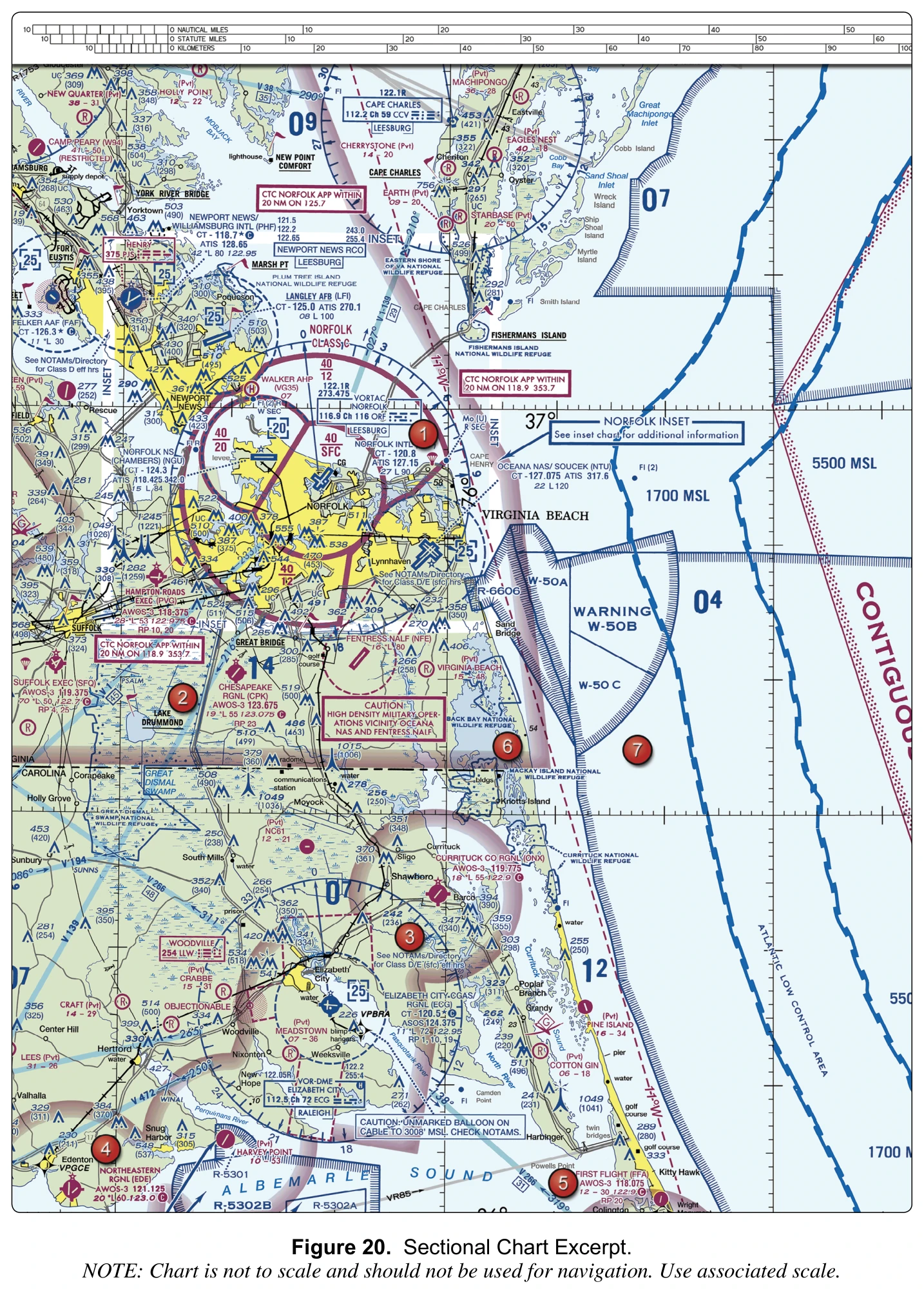
(Refer to FAA-CT-8080-2H, Figure 20, area 1.) Area 1 is northeast of Norfolk Intl, between the inner Class C circle and the outer Class C boundary. What are the vertical limits of the Class C airspace over area 1?
Answer: B. From 1,200 feet MSL to 4,000 feet MSL.
Area 1 lies in the outer shelf between the inner circle and the outer ring, and the magenta label printed in that shelf, at the top of the ring north of the airport, reads 40 over 12. The Chart User's Guide states that Class C ceiling and floor altitudes are MSL values shown in solid magenta figures with the last two zeros eliminated, so the Class C over area 1 begins at 1,200 feet MSL and tops out at 4,000 feet MSL. "Surface to 4,000 feet MSL" describes the 40 over SFC inner circle around the airport, which does not reach area 1. The 40 over 20 label belongs to the separate sector west of Norfolk Intl. A small UA flying low at area 1 stays beneath this shelf, but the pilot still has to check what airspace lies under it.
Source
Class C Airspace is shown on Sectionals and TACs. The MSL ceiling and floor altitudes of each sector are shown in solid magenta figures with the last two zeros eliminated.
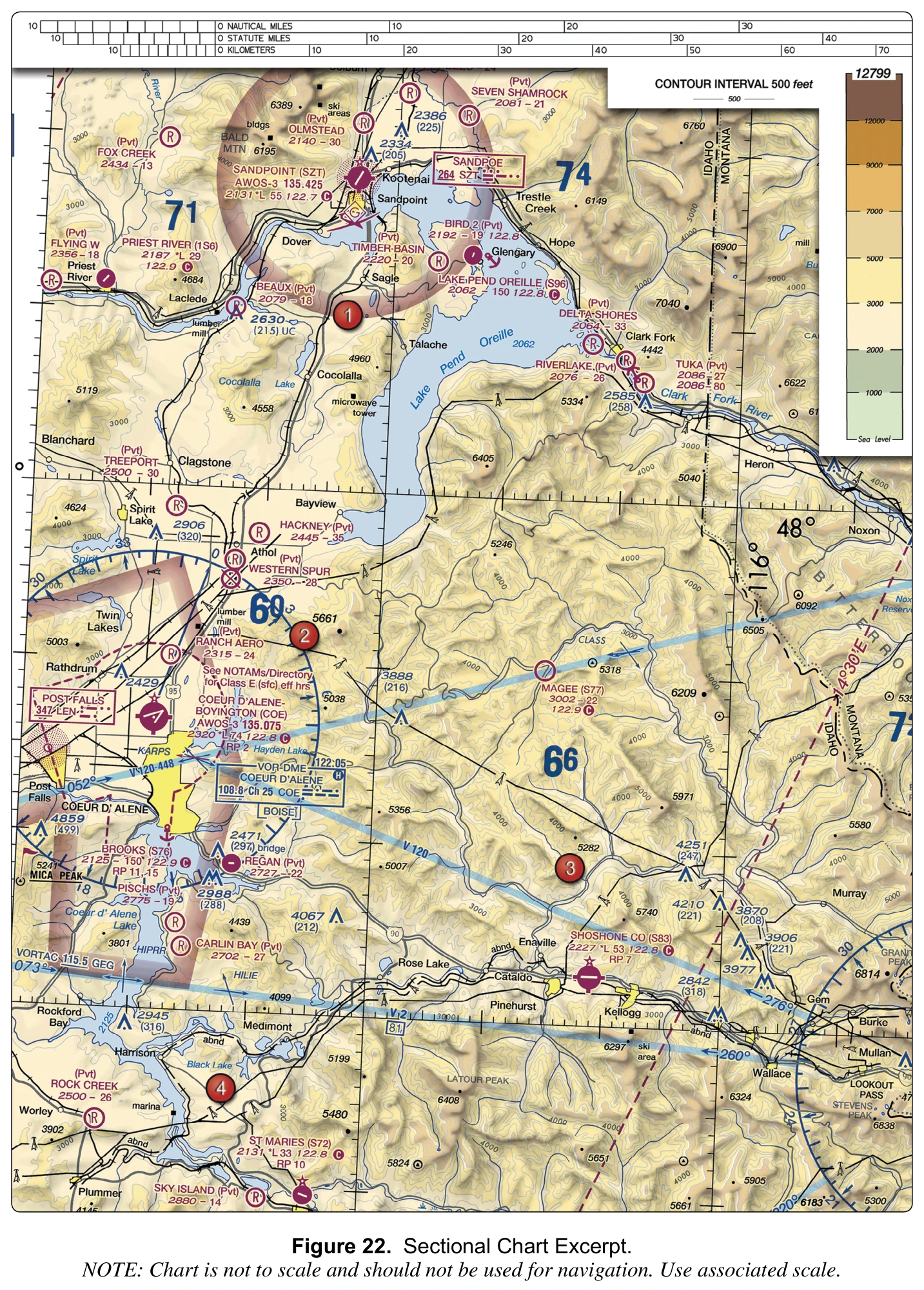
(Refer to FAA-CT-8080-2H, Figure 22, area 3.) In the quadrant that contains area 3, the highest elevation charted is the 6209-foot peak northeast of area 3, and the quadrant's maximum elevation figure reads 66. Why is the MEF 6,600 feet rather than 6,209 feet?
Answer: B. Allowances of 100 feet for elevation error and 200 feet for uncharted obstacles are added, and the total is rounded up to the next 100 feet.
The Chart User's Guide lists the steps when a natural terrain feature is the highest point in a quadrant: take its elevation, add the possible vertical error of the source (100 feet), add a 200-foot allowance for uncharted natural or man-made obstacles, and round up to the next higher hundred-foot level. Starting from the 6209-foot peak, 6,209 + 100 + 200 = 6,509, which rounds up to 6,600 feet MSL, printed as 66. The MEF is an MSL value, not a height above a valley floor, and it has nothing to do with the Part 107 altitude limit; adding 400 feet would give 6,609, which rounds up to 67. The MEF gives a remote pilot a quick, conservative picture of how high terrain and obstacles reach.
Source
Add the possible vertical error of the source to the above figure (100' or 1/2 the contour interval when interval on source exceeds 200').
Add a 200' allowance for uncharted natural or manmade obstacles.
Round the figure up to the next higher hundred-foot level.
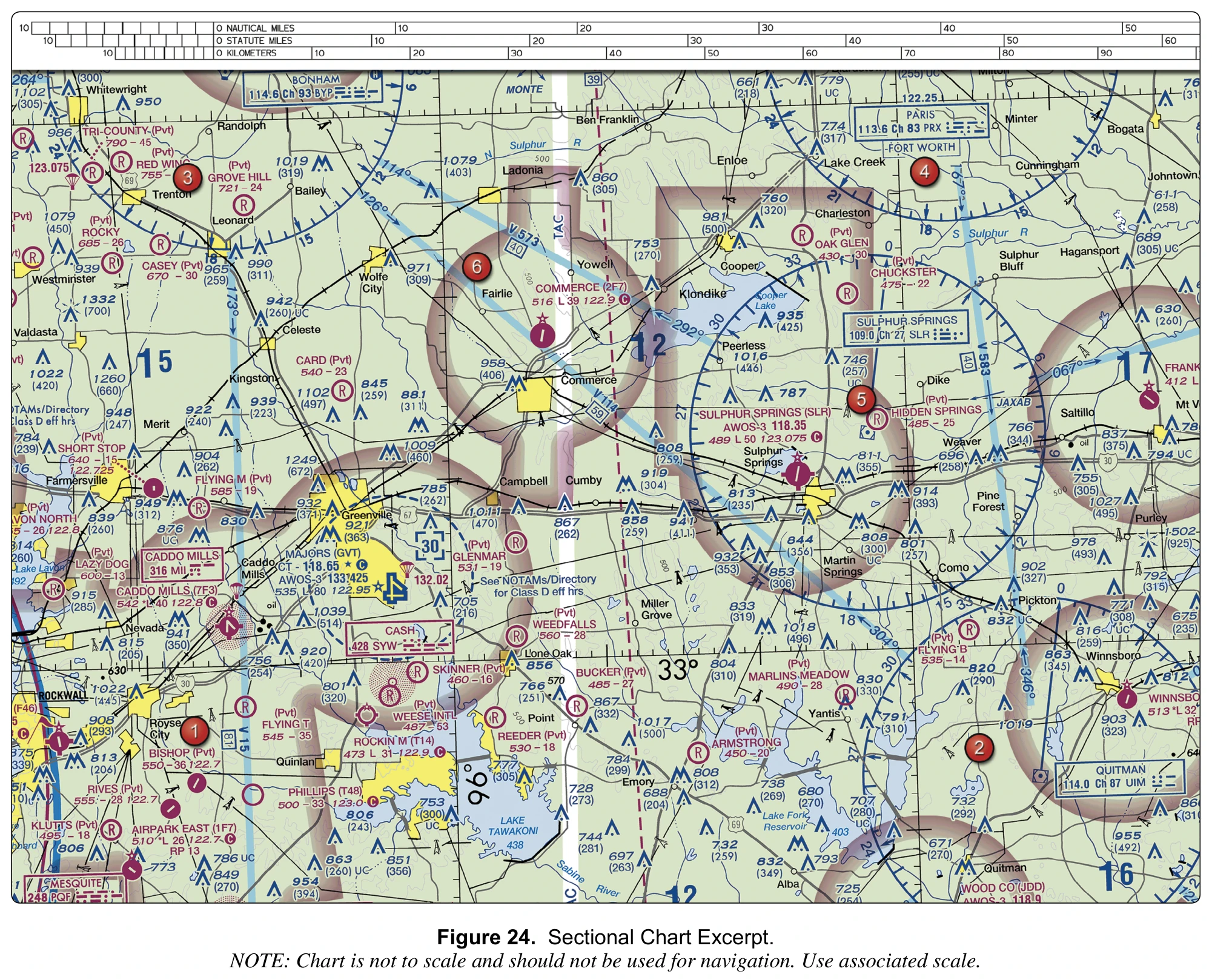
(Refer to FAA-CT-8080-2H, Figure 24.) A remote pilot plans a low-level flight over the yellow-tinted city of Greenville, next to Majors (GVT). Obstructions charted in the city include 932 (371) and 921 (363). What should the pilot conclude about structures that are not charted there?
Answer: C. Some may be up to about 299 feet AGL, because obstacles in yellow city tint are typically charted only above 299 feet AGL.
The Chart User's Guide says sectionals typically show man-made obstacles extending more than 200 feet AGL, or more than 299 feet AGL in yellow city tint. Greenville is shown in yellow tint, so buildings and towers up to about 299 feet AGL normally are not charted there; the labels 932 (371) and 921 (363) mark only taller structures. The AIM adds that many structures at and below 200 feet AGL are not marked, lighted, or charted, and that new obstructions may not be on current charts. A site survey and a NOTAM check are needed before flying low over the city.
Source
Sectional Charts and Terminal Area (TACs) typically show man-made obstacles extending more than 200' Above Ground Level (AGL), or more than 299' AGL in yellow city tint.
At and below 200 feet AGL there are numerous power lines, antenna towers, etc., that are not marked and lighted and/or charted as obstructions
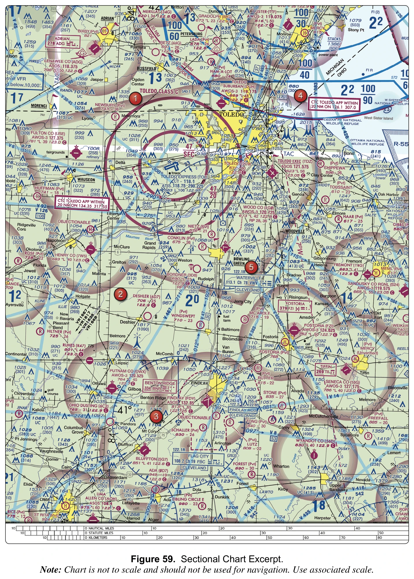
(Refer to FAA-CT-8080-2H, Figure 59, area 2.) Just south of Deshler, below area 2, the symbol for an obstruction 1,000 feet or more AGL is labeled 1817 (1090). A remote pilot will photograph a field near this tower. According to the Remote Pilot Study Guide, how far horizontally should the small UA stay from tall skeletal structures such as antenna towers?
Answer: A. At least 2,000 feet, because guy wires can extend about 1,500 feet from the structure.
The label shows a tower whose top is 1,817 feet MSL and that stands 1,090 feet above the ground, drawn with the symbol for obstructions 1,000 feet and higher AGL. The Remote Pilot Study Guide, like the AIM, describes skeletal structures such as radio and television antenna towers that exceed 1,000 feet AGL, warns that most are supported by guy wires that are very hard to see and can extend about 1,500 feet horizontally, and says such structures should be avoided horizontally by at least 2,000 feet. The 400-foot radius in § 107.51(b) only allows a higher altitude while inspecting a structure; it is not a safe distance from guy wires. A distance equal to the tower's height has no basis.
Source
numerous skeletal structures, such as radio and television antenna towers, that exceed 1,000 feet AGL
These wires can extend about 1,500 feet horizontally from a structure; therefore, all skeletal structures should be avoided horizontally by at least 2,000 feet.
Most skeletal structures are supported by guy wires which are very difficult to see in good weather and can be invisible at dusk or during periods of reduced visibility.
(Refer to FAA-CT-8080-2H, Figure 59.) Below the Toledo Approach frequency box southwest of Toledo Express, the word OBJECTIONABLE is printed next to a heliport symbol. What does it indicate?
Answer: C. An objectionable airspace determination has been made for the landing area, based on factors such as conflicting traffic patterns or nearby obstacles.
The Chart User's Guide says the type OBJECTIONABLE associated with an airport symbol indicates that an objectionable airspace determination has been made for the airport, based on factors such as conflicting traffic patterns with another airport, hazardous runway conditions, or natural or man-made obstacles close to the landing area. It does not close the facility or create a no-fly zone for small UA. Helicopters may still use the heliport, so a remote pilot working nearby must avoid interfering with its operations and traffic patterns, as § 107.43 requires for any airport, heliport, or seaplane base.
Source
The type "OBJECTIONABLE" associated with an airport symbol indicates that an objectionable airspace determination has been made for the airport
Objectionable airspace determinations are based upon a number of factors including conflicting traffic patterns with another airport, hazardous runway conditions, or natural or man-made obstacles in close proximity to the landing area.
No person may operate a small unmanned aircraft in a manner that interferes with operations and traffic patterns at any airport, heliport, or seaplane base.
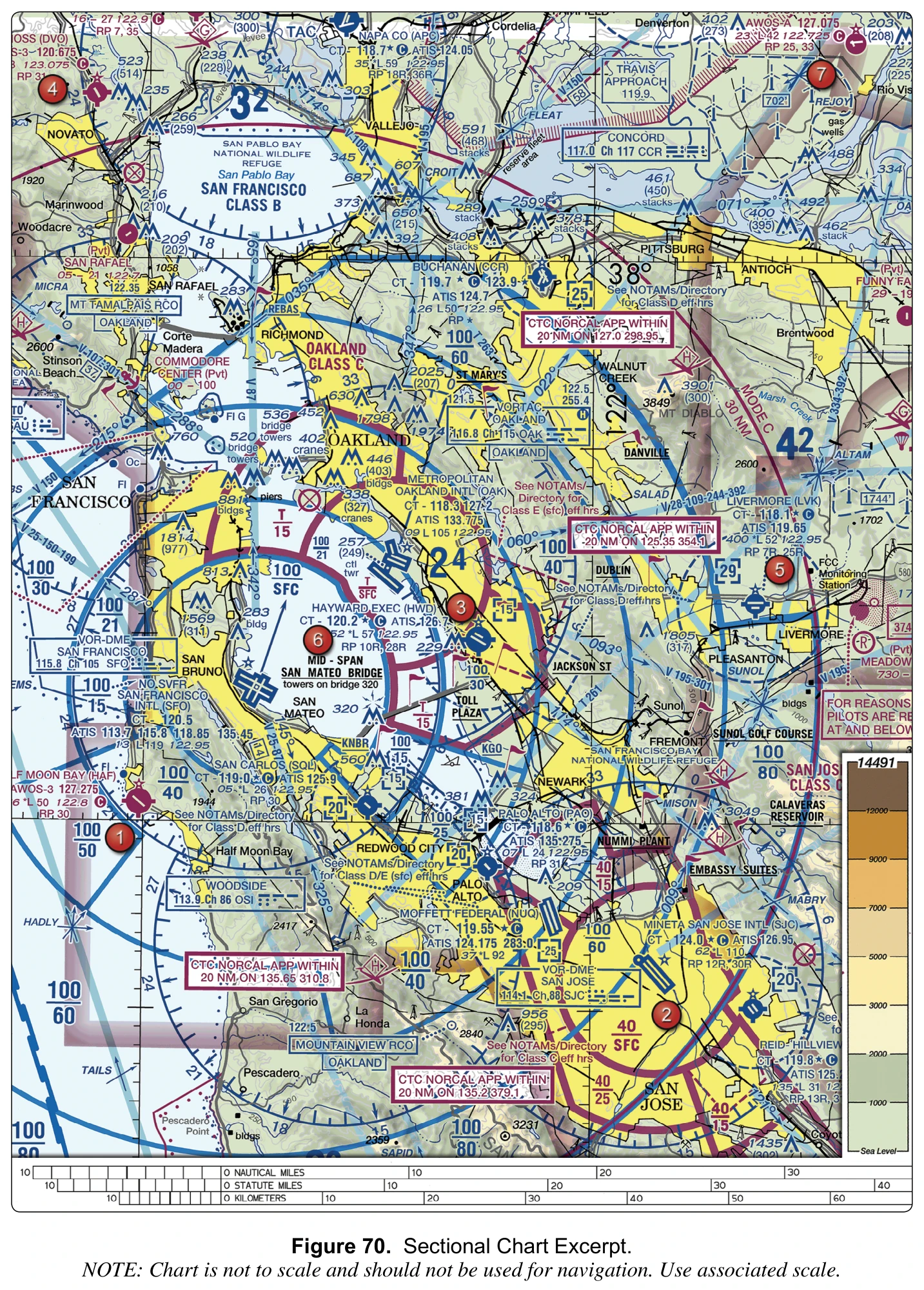
(Refer to FAA-CT-8080-2H, Figure 70.) Northeast of Livermore (LVK), wind turbine symbols are enclosed by a dashed outline containing the boxed figure 1744'. What does the boxed figure represent?
Answer: B. The MSL elevation of the highest wind turbine within the farm.
The Chart User's Guide says wind turbine farms are portrayed with an outline around representative turbine symbols, and that a boxed elevation figure gives the MSL elevation of the highest wind turbine within the area. 1744' is therefore the top of the tallest turbine above mean sea level; heights of individual turbines above ground are not given. Maximum elevation figures are large blue numerals without a box. The guide also warns that turbine obstruction lights sit on the nacelle, which can be 200 to 300 feet below the rotating blade tips, so the blade tips themselves may be unlit.
Source
A boxed elevation figure representing the MSL elevation of the highest wind turbine within the area shall be placed inside the farm or, if space is limited, just outside.
Wind turbine obstruction lights are located on top of the nacelle (generator) at the hub of wind turbines, which in some cases can be 200-300' below the rotating blade tips.
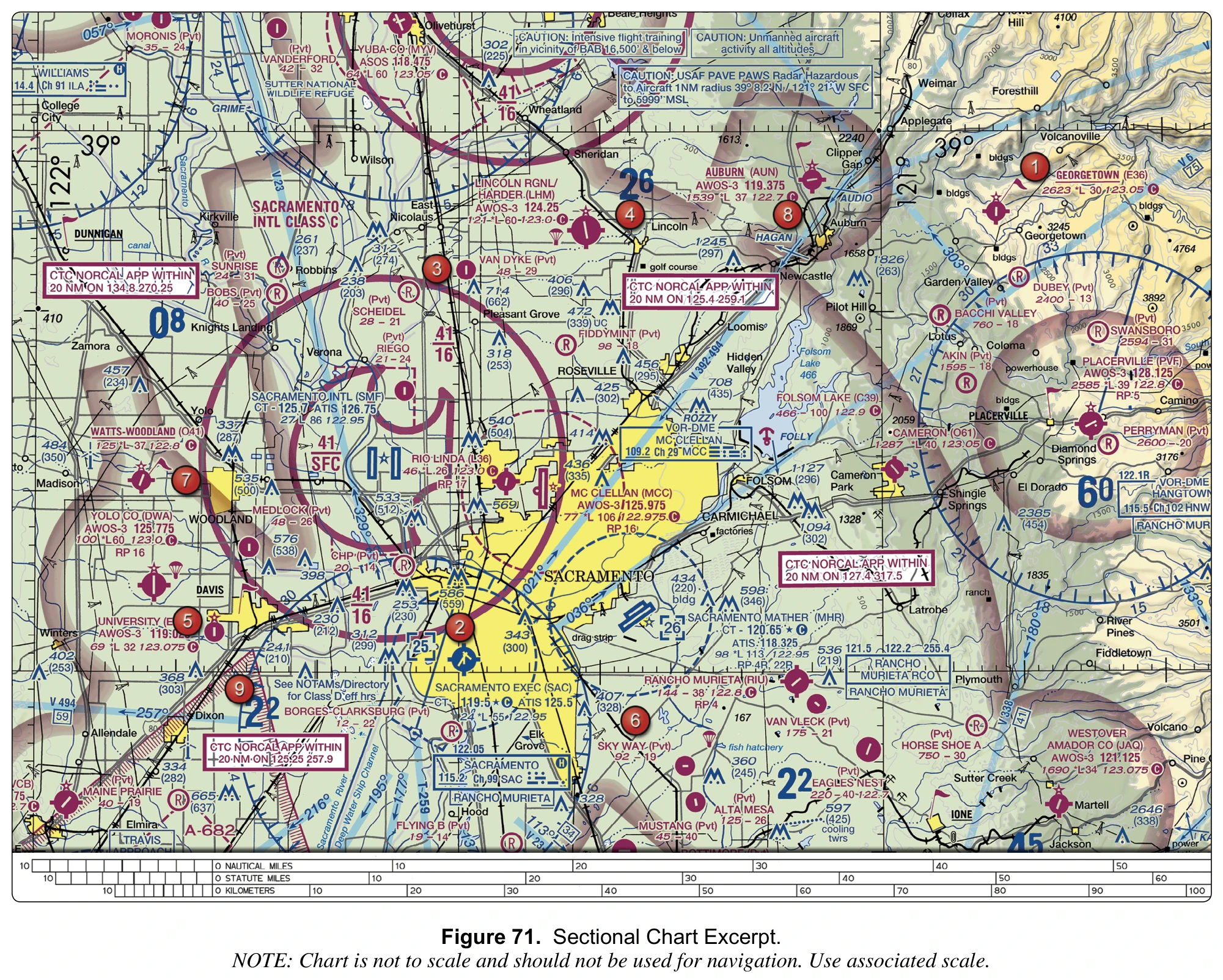
(Refer to FAA-CT-8080-2H, Figure 71.) Near the top of the excerpt, a boxed note reads "CAUTION: Unmanned aircraft activity all altitudes." What is the best interpretation for a remote pilot planning a flight in that vicinity?
Answer: B. Other unmanned aircraft, possibly large and fast, may operate there at any altitude, so check NOTAMs and keep a vigilant lookout.
The note is a caution, not a regulatory boundary. The AIM explains that unmanned aircraft range from several pounds to the size of a commercial transport aircraft, that they may be found operating at virtually any altitude and any speed, and that approved UAS operations typically require a NOTAM describing the operation. A remote pilot should therefore check NOTAMs for the activity and watch for other aircraft. Nothing in the note relaxes the 400-foot AGL limit of § 107.51, and restricted areas are charted with their own blue hatched boundary and R-number, so the caution creates no permission requirement.
Source
UA may be found operating at virtually any altitude and any speed.
Sizes of UA can be as small as several pounds to as large as a commercial transport aircraft.
typically require the issuance of a NOTAM describing the operation to be conducted.
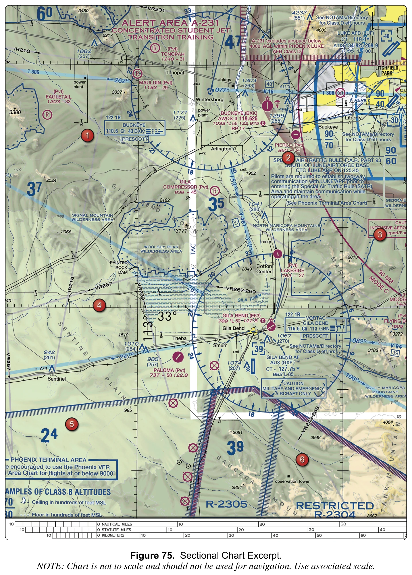
(Refer to FAA-CT-8080-2H, Figure 75, area 4.) What are the approximate coordinates of area 4?
Answer: B. 33°00'N latitude, 113°06'W longitude.
Area 4 sits on the parallel labeled 33°, and parallels measure latitude north of the equator, so its latitude is 33°00'N. The nearest meridian, labeled 113°, runs just east of area 4. Meridians measure longitude east or west of the Prime Meridian, and for places west of it, such as the United States, the values grow toward the west, so a point west of the 113° meridian lies at more than 113°W. Counting the minute ticks along the parallel, area 4 is about 6 minutes west of the meridian, roughly 113°06'W. 112°54'W would lie east of the meridian, and 33°06'N, 113°00'W swaps the minutes between latitude and longitude.
Source
Circles parallel to the equator (lines running east and west) are parallels of latitude. They are used to measure degrees of latitude north (N) or south (S) of the equator.
is used as the zero line from which measurements are made in degrees east (E) and west (W) to 180°.
Latitude. Measurement north or south of the equator in degrees, minutes, and seconds.
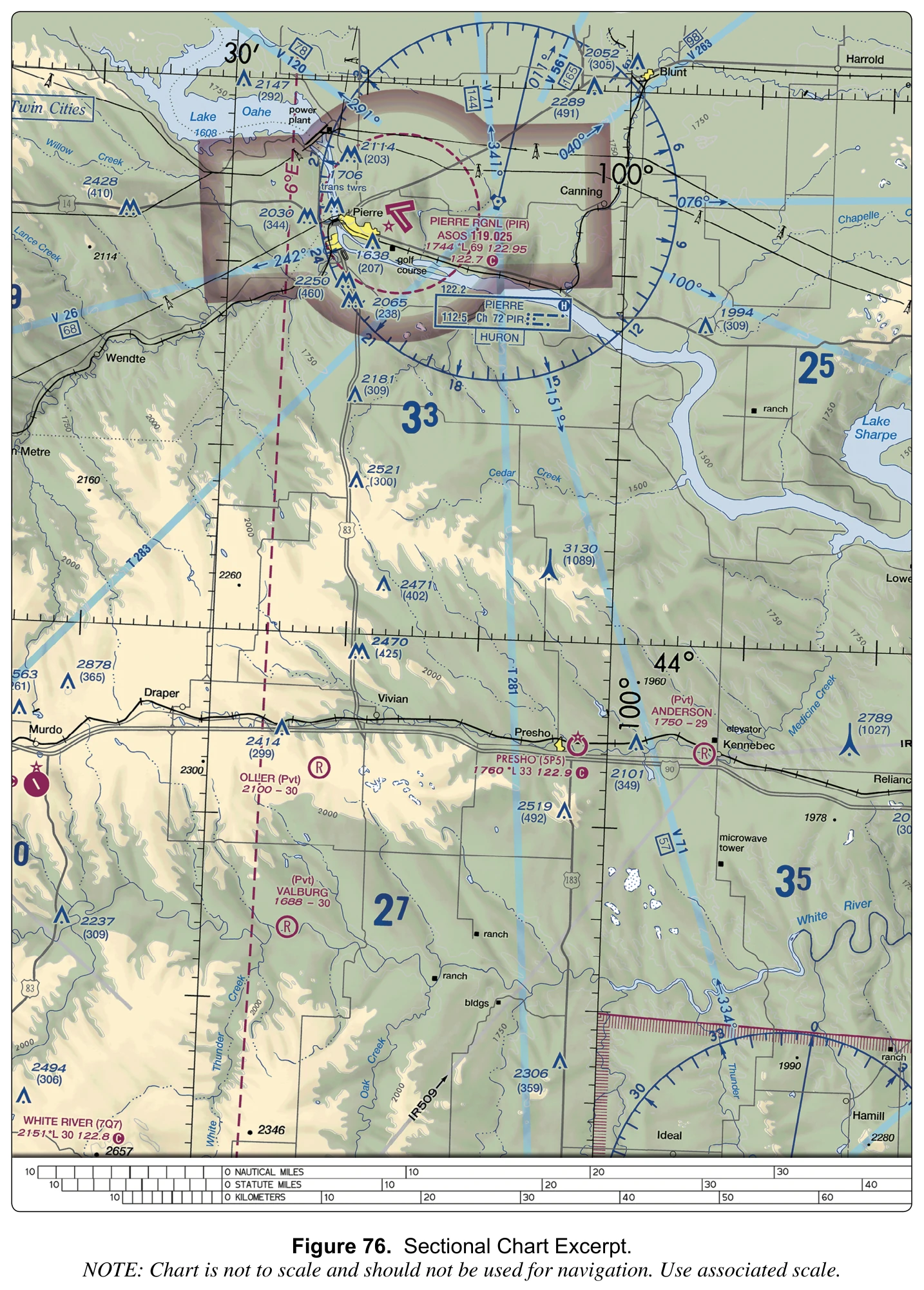
(Refer to FAA-CT-8080-2H, Figure 76.) The Pierre Rgnl (PIR) data block shows ASOS 119.025, then 1744 *L 69 122.95, then 122.7 followed by a circled C. On which frequency should a remote pilot listen for manned pilots' position reports near the airport?
Answer: A. 122.7 MHz.
Pierre Rgnl's data block is magenta, so the airport has no control tower. The circled C follows the Common Traffic Advisory Frequency, so 122.7 is where pilots self-announce, and the Chart Supplement entry in Figure 77 lists the same CTAF 122.7 with UNICOM 122.95. The 122.95 on the elevation line is therefore the UNICOM, an aeronautical advisory station that is separate from the CTAF at this airport. ASOS 119.025 broadcasts automated weather, not traffic calls. Listening on 122.7 tells a remote pilot when manned aircraft are arriving or departing nearby.
Source
Follows the Common Traffic Advisory Frequency (CTAF)
COMMUNICATIONS: CTAF 122.7 UNICOM 122.95
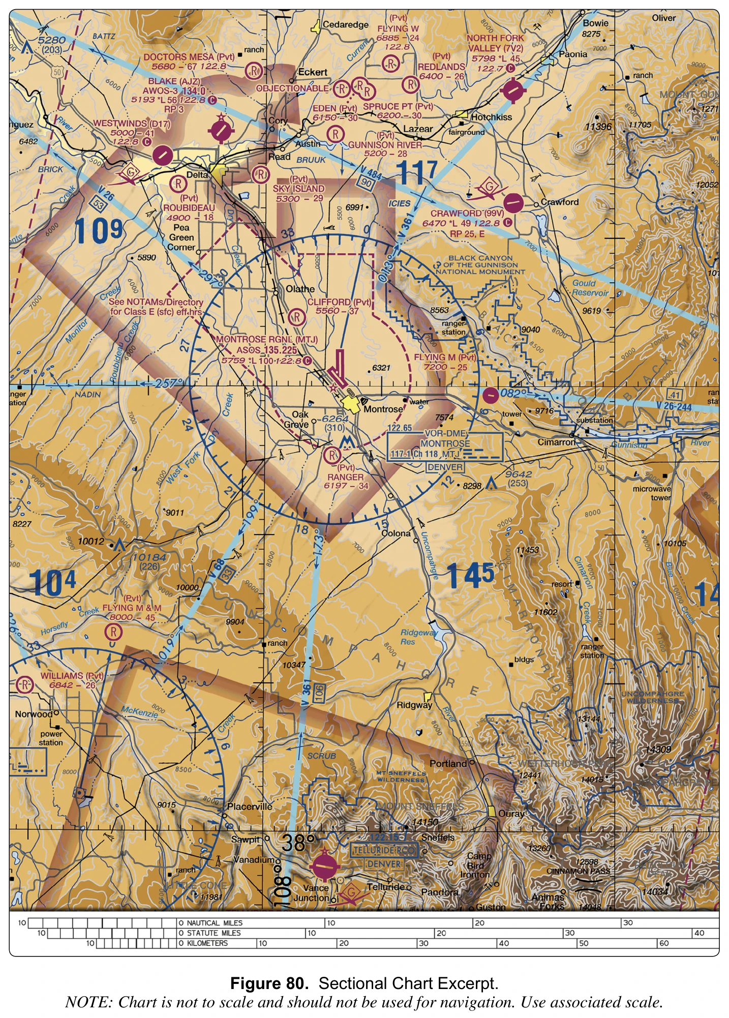
(Refer to FAA-CT-8080-2H, Figure 80.) East of Montrose, the area labeled BLACK CANYON OF THE GUNNISON NATIONAL MONUMENT is outlined by a blue line with a row of dots along its inside. What does this boundary depict?
Answer: B. A special conservation area, such as a national park or monument, over which pilots are requested to stay at least 2,000 feet above the surface.
The Chart User's Guide lists this blue boundary under Special Conservation Areas: national parks, wildlife refuges, primitive and wilderness areas, and similar lands. The AIM requests pilots to maintain at least 2,000 feet above the surface of national parks and monuments administered by the National Park Service and other listed areas, and notes that federal statutes prohibit certain flight activities or set altitude restrictions over some of them. A small UA cannot meet a 2,000-foot request, so check the managing agency's rules before planning a flight there. Restricted areas use a blue hatched boundary and an R-number, and national security areas use a broken magenta line.
Source
Special Conservation Areas National Park, Wildlife Refuge, Primitive and Wilderness Areas, etc.
Pilots are requested to maintain a minimum altitude of 2,000 feet above the surface of the following: National Parks, Monuments, Seashores, Lakeshores, Recreation Areas and Scenic Riverways administered by the National Park Service
Federal statutes prohibit certain types of flight activity and/or provide altitude restrictions over designated U.S. Wildlife Refuges, Parks, and Forest Service Areas.
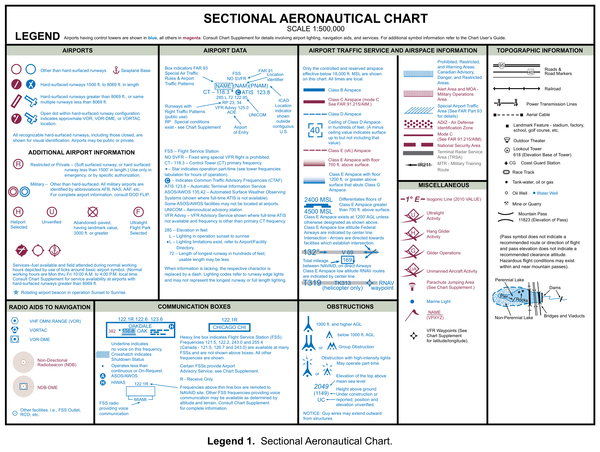
(Refer to FAA-CT-8080-2H, Legend 1.) In the Obstructions section, some obstruction symbols are drawn with flash marks at the top. What do these marks indicate?
Answer: B. High-intensity obstruction lights, which may operate only part-time.
The legend labels this symbol "Obstruction with high-intensity lights" and adds "May operate part-time." The Chart User's Guide explains that obstacles with high-intensity strobe lighting systems may operate part-time or by proximity activation, so a remote pilot cannot count on seeing the lights flashing. The flash marks say nothing about radio emissions, and unverified obstructions are labeled UC instead. Plan to locate such a tower visually before launch and keep the small UA well clear of it and of any guy wires.
Source
Obstruction with high-intensity lights May operate part-time
Obstacles with high-intensity strobe lighting systems may operate part-time or by proximity activation
A remote pilot checks NOTAMs only for the identifier of the nearest airport and finds nothing relevant. The site is 15 miles from that airport, beneath charted special use airspace. What else does the AIM say pilots should review?
Answer: A. NOTAMs for the ARTCC area, which can cover SUA activation, TFRs, and UAS activity.
AIM 5-1-3c tells pilots to also review NOTAMs for the ARTCC area in which the flight will be operating, for example Washington Center (ZDC), because these NOTAMs may affect the planned flight; they cover operations such as altitude reservations, special use airspace, TFRs, GPS, wind turbines, and unmanned aircraft systems. AIM 3-4-9b adds that an airspace NOTAM is issued when SUA requires a NOTAM for activation and that pilots should check ARTCC NOTAMs for airspace activation. Airport NOTAMs do not list every restriction within 30 NM, so stopping there is wrong. A chart edition cannot show day-to-day activation, so waiting for the next sectional is also wrong.
Source
Pilots should also review NOTAMs for the ARTCC area (for example, Washington Center (ZDC), Cleveland Center (ZOB), etc.) in which the flight will be operating.
Flight Restrictions (TFR), Global Positioning System (GPS), Flight Data Center (FDC) changes to routes, wind turbine, and Unmanned Aircraft System (UAS).
Pilots should check ARTCC NOTAMs for airspace activation.
A remote pilot receives a Standard Briefing from Flight Service for an operation near a military operations area and a military training route. Which NOTAM information is an "upon request" item that the pilot must specifically ask for?
Answer: B. NOTAMs for MOAs, military training routes, and warning areas.
AIM 7-1-5b lists what a Standard Briefing automatically includes under NOTAMs: available NOTAM (D) information pertinent to the proposed flight, including special use airspace NOTAMs for restricted areas, aerial refueling, and night vision goggles, plus prohibited areas P-40, P-49, and P-56 and the Washington, DC SFRA. A note adds that other SUA NOTAMs (D), such as MOA, MTR, and warning area NOTAMs, are upon-request briefing items, so the remote pilot must ask for them. NOTAMs general in nature, such as open-duration special security instructions, are also briefed only on request. AIM 5-1-1c encourages pilots to remind the specialist if NOTAM information has not been received.
Source
Other SUA NOTAMs (D), such as military operations area (MOA), military training route (MTR), and warning area NOTAMs, are considered "upon request" briefing items
Available NOTAM (D) information pertinent to the proposed flight, including special use airspace (SUA) NOTAMs for restricted areas, aerial refueling, and night vision goggles (NVG).
Prohibited Areas P-40, P-49, P-56, and the special flight rules area (SFRA) for Washington, DC.
A restricted area near a remote pilot's site lists permanent times of use of 0800-1700 local, Monday through Friday, in the chart's tabulation. On a Wednesday morning the pilot checks NOTAMs and finds none for the area. What should the pilot conclude?
Answer: C. It may still be active; NOTAMs are not issued to announce permanently listed times of use.
The Chart Users' Guide warns that a NOTAM addressing activation will not be issued to announce permanently listed times of use; the chart tabulation itself gives each area's altitude, time of use, and controlling agency. AIM 3-4-9b explains that an airspace NOTAM is issued for SUA when the SUA requires a NOTAM for activation. So the absence of a NOTAM says nothing about whether the area is in use during its listed times, and assuming it is inactive is wrong. Assuming the area was released is also wrong, and in any case § 107.45 requires permission from the using or controlling agency before a small UA operates in a restricted area. AIM 3-4-9a notes that SUA status can be requested from that agency.
Source
Users need to be aware that a NOTAM addressing activation will NOT be issued to announce permanently listed times of use.
An airspace NOTAM will be issued for SUA when the SUA airspace (permanent and/or temporary) requires a NOTAM for activation.
No person may operate a small unmanned aircraft in prohibited or restricted areas unless that person has permission from the using or controlling agency, as appropriate.
For pilots who already have a study routine.
$19one-time
Recommended
Build a routine, fix weak areas and rehearse the exam.
$39one-time
Add a printable reference for your final revision.
$59one-time
Already purchased? Restore or manage your access. Access lasts while this site operates.
Help us improve Part 107 HQ with page visits and feature-use counts. Your answers, scores, email and access code stay out of analytics. Privacy policy