Question Bank
For pilots who already have a study routine.
$19one-time
- All 765 practice questions
- Full explanations & official sources
- All 64 current-chart questions
- Topic drills & missed-question review
From October 26, 2026, the FAA Remote Pilot test includes image-based questions that are not in the testing supplement, using images from the latest sectional charts. These Part 107 practice questions are built the same way: every image is an excerpt of a current FAA sectional chart, and you read airspace, airport and obstacle information from it.
Current set: 64 questions from the sectional charts effective September 3, 2026. 16 are free to practice; a study plan unlocks the full set.
Each answer comes from FAA airspace and airport data for the same chart edition, not from someone reading the picture, and the explanation shows you which symbol on the chart gives it away. Sectional charts are republished every 56 days; we rebuild these questions for each new edition.
All of these come from the FAA sectional chart legend (FAA-CT-8080-2H, Legend 1) and the FAA Aeronautical Chart User's Guide; check them whenever a symbol is new to you. The explanation of each question names the symbol that answers it.
A new chart excerpt can test a familiar rule. These free lessons show how to read the altitude reference, boundary or frequency before choosing an answer.
Read airport elevations and obstacle heights, then work through a local-ground example.
Read the chart lesson →Compare Class E chart symbols and identify the floor at your point.
Compare the symbols →Use the circled C instead of guessing from a nearby UNICOM or weather frequency.
Read the frequency lesson →Preparing for the new images? Read what changes on October 26, 2026. Our exercises are original study questions using FAA charts; they do not reproduce confidential exam questions.
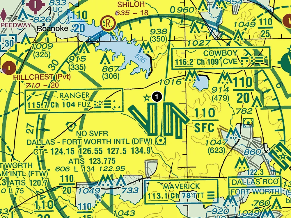
(Refer to the figure, area 1.) What is the elevation of Dallas-Fort Worth Intl (DFW)?
Answer: C. 606 feet MSL
606 feet MSL. In the airport data block, the line that starts with 606 gives the field elevation in feet above mean sea level, followed by the lighting code and the length of the longest runway. The 134 on that line is the length of the longest runway in hundreds of feet (about 13,400 feet), not an elevation. 606 feet AGL makes no sense for a field elevation: the airport is the ground, and the chart gives its height above mean sea level.
Source
606.4
The elevation of an airport is the highest point on the usable portion of the landing areas.
Length of longest runway in hundreds of feet; usable length may be less
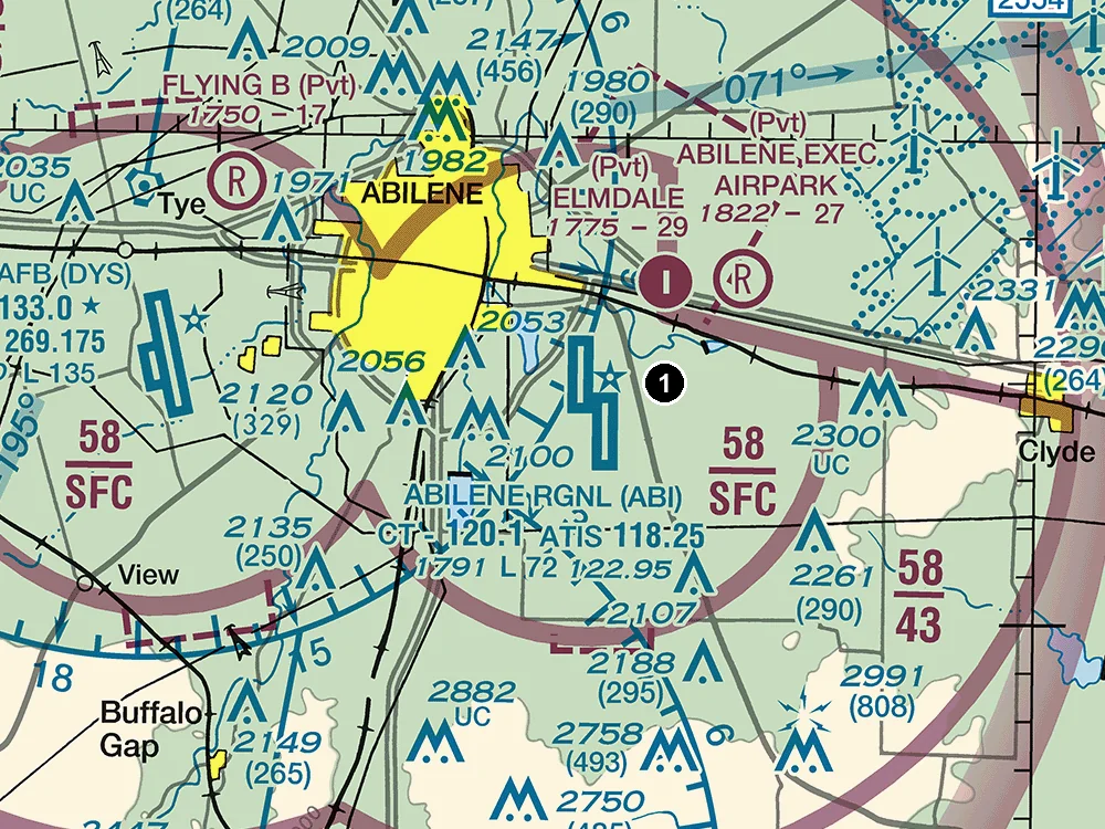
(Refer to the figure, area 1.) What class of airspace is at the surface over Abilene Rgnl (ABI)? Assume any control tower in the figure is operating.
Answer: A. Class C
Class C. Abilene Rgnl sits inside solid magenta circles, the chart symbol for Class C airspace. The inner circle is labeled 58/SFC: the top number is the ceiling in hundreds of feet MSL (5,800 feet MSL) and SFC means this part begins at the surface. Class B would be drawn with solid blue lines, and Class D with a dashed blue line. Flying a small UA here requires prior ATC authorization under 14 CFR 107.41.
Source
CLASS_C
SFC
The MSL ceiling and floor altitudes of each sector are shown in solid magenta figures with the last two zeros eliminated.
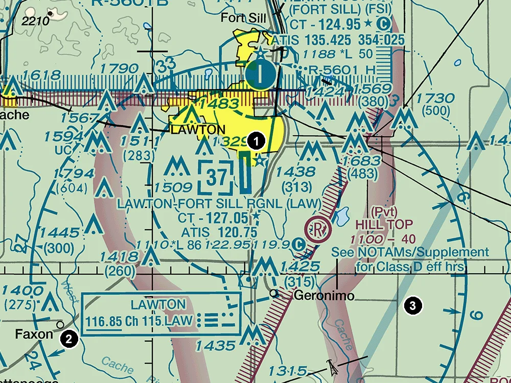
(Refer to the figure, area 1.) What is the ceiling of the Class D airspace at Lawton-Fort Sill Rgnl (LAW)?
Answer: C. 3,700 feet MSL
3,700 feet MSL. The Class D airspace is outlined by a dashed blue line, and the number in the dashed blue box, 37, is its ceiling in hundreds of feet MSL. Altitudes of charted airspace are MSL, so reading it as 3,700 feet AGL is wrong: that would put the top about 1,110 feet higher, the field elevation. 2,600 feet MSL is the ceiling minus the field elevation, which is roughly the height of the airspace above the airport, not an MSL altitude.
Source
3700
TI
Class D Airspace Altitude in hundreds of feet MSL
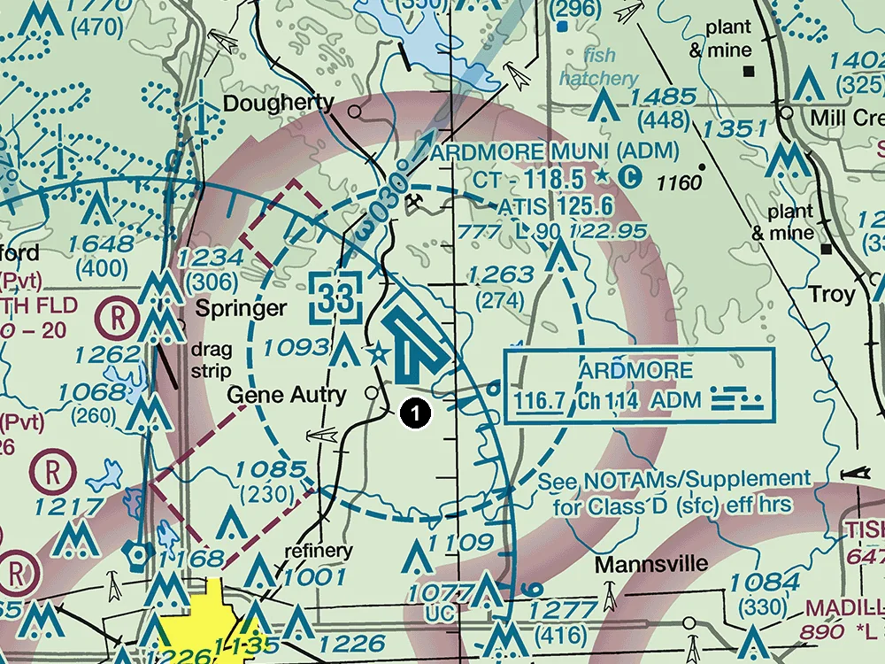
(Refer to the figure, area 1.) What class of airspace is at the surface over Ardmore Muni (ADM)? Assume any control tower in the figure is operating.
Answer: C. Class D
Class D. Ardmore Muni is printed in blue, so it has a control tower, and it sits inside a dashed blue line, the chart symbol for Class D airspace, which starts at the surface. The number in the dashed box gives the Class D ceiling in hundreds of feet MSL. Class C would be drawn with solid magenta circles, not a dashed blue line. Class G is wrong while the tower is open because the dashed blue boundary makes the airspace controlled down to the ground. Before flying here a remote pilot needs ATC authorization under 14 CFR 107.41, normally through LAANC or FAA DroneZone.
Source
CLASS_D
SFC
Class D Airspace is identified with a blue dashed line.
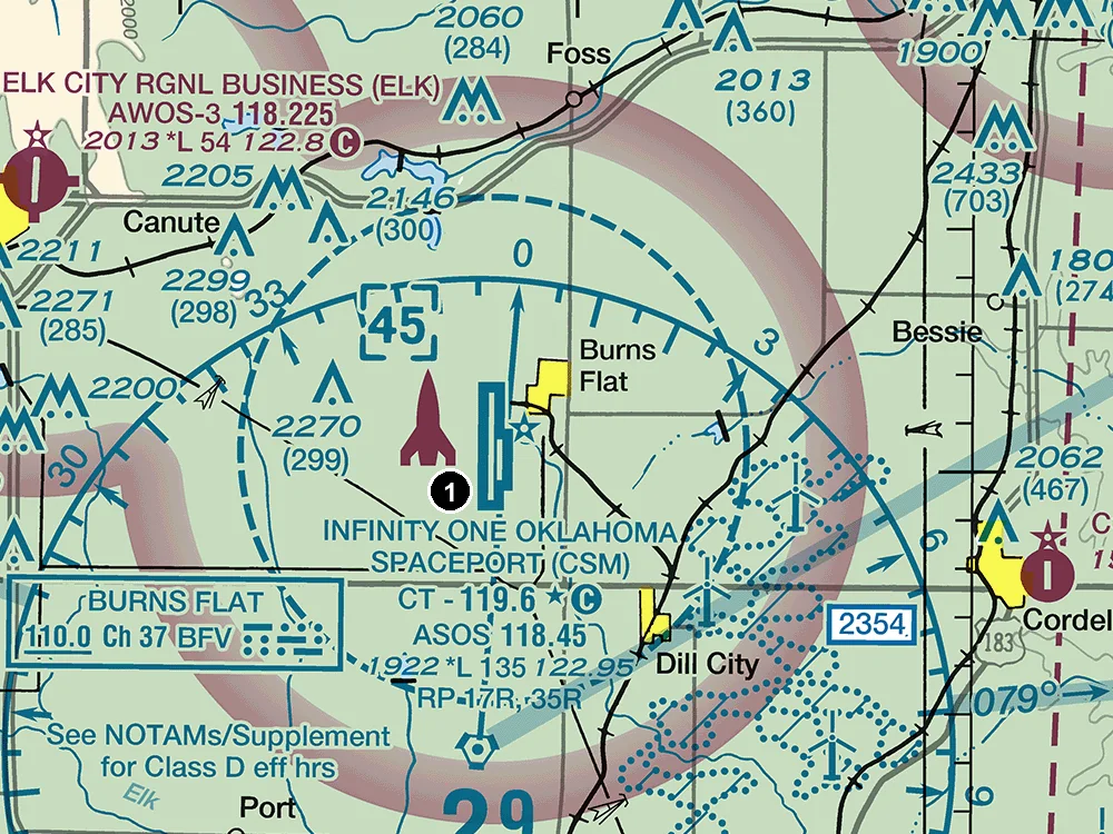
(Refer to the figure, area 1.) A remote pilot plans an early-morning flight near Infinity One Oklahoma Spaceport (CSM) before its control tower opens. Which frequency should be monitored as the CTAF?
Answer: A. 119.6 MHz
119.6 MHz. The airport is printed in blue, so it has a control tower, and 'CT - 119.6' gives the tower's primary frequency. The star after it means the tower operates part-time, and the circled C means the same frequency is the Common Traffic Advisory Frequency when the tower is closed. 118.45 is the ASOS automated weather frequency; 122.95 is UNICOM, used for services such as fuel requests, so neither is the CTAF.
Source
119.6
Star indicates operation part-time.
Follows the Common Traffic Advisory Frequency (CTAF)
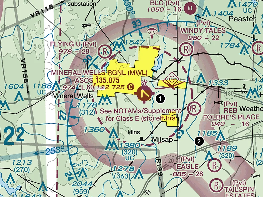
(Refer to the figure, area 2.) What is the floor of the Class E airspace at area 2?
Answer: A. 700 feet AGL
700 feet AGL. Area 2 lies just inside the fuzzy magenta band (vignette) that rings Mineral Wells, on the side toward which the band fades. A magenta vignette marks a 700-foot floor: its sharp outer edge is the limit, and on the faded side Class E airspace begins at 700 feet AGL, with Class G below. Area 2 is outside the dashed magenta Class E surface-area line around the airport, so the floor is not the surface, and 1,200 feet AGL applies only beyond the vignette's sharp outer edge. A small UA flying below 400 feet AGL there stays in Class G airspace.
Source
700
SFC
Controlled airspace floors of 700' above the ground are defined by a magenta vignette
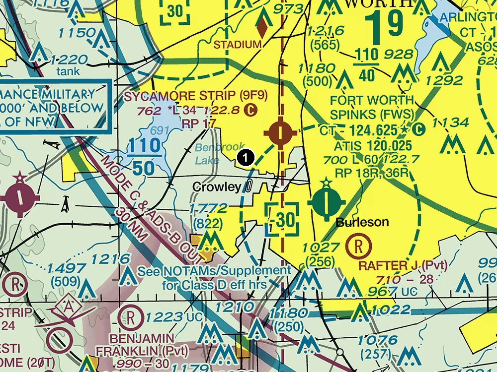
(Refer to the figure, area 1.) What is the ceiling of the Class B airspace above area 1?
Answer: A. 11,000 feet MSL
11,000 feet MSL. Area 1 lies in the Class B sector labeled 110 over 50. In these solid blue labels the top number is the ceiling and the bottom number the floor, both in hundreds of feet MSL with the last two zeros left off, so this sector spans 5,000 to 11,000 feet MSL. The ceiling is MSL, not AGL, and 5,000 feet MSL is the floor of this sector, where the Class B airspace begins.
Source
11000
MSL
The MSL ceiling and floor altitudes of each sector are shown in solid blue figures with the last two zeros omitted.
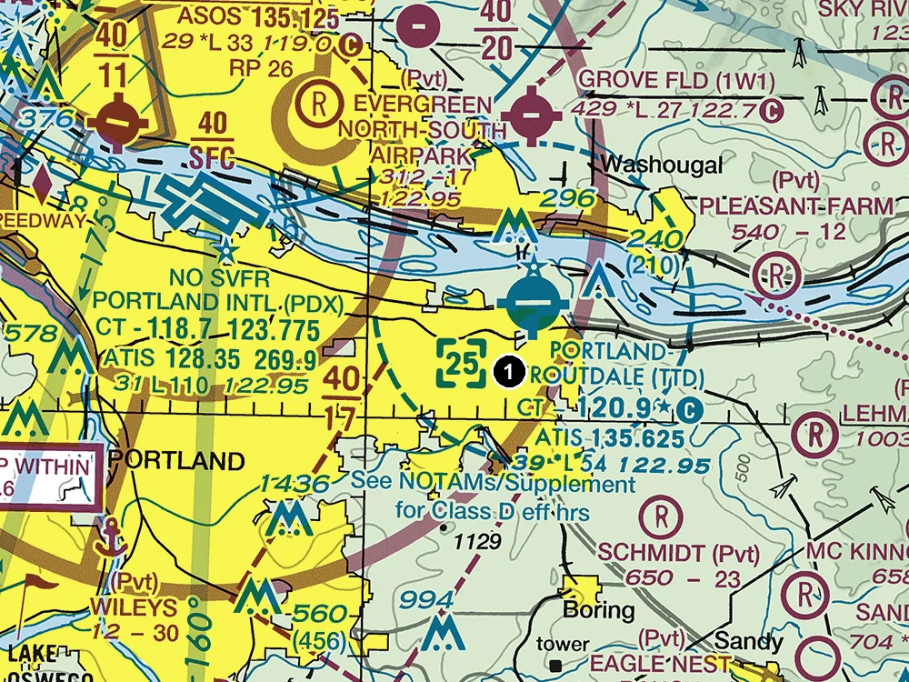
(Refer to the figure, area 1.) A remote pilot plans an early-morning flight near Portland-Troutdale (TTD) before its control tower opens. Which frequency should be monitored as the CTAF?
Answer: B. 120.9 MHz
120.9 MHz. The airport is printed in blue, so it has a control tower, and 'CT - 120.9' gives the tower's primary frequency. The star after it means the tower operates part-time, and the circled C means the same frequency is the Common Traffic Advisory Frequency when the tower is closed. 135.625 is the ATIS frequency (recorded airport information); 122.95 is UNICOM, used for services such as fuel requests, so neither is the CTAF.
Source
120.9
Star indicates operation part-time.
Follows the Common Traffic Advisory Frequency (CTAF)
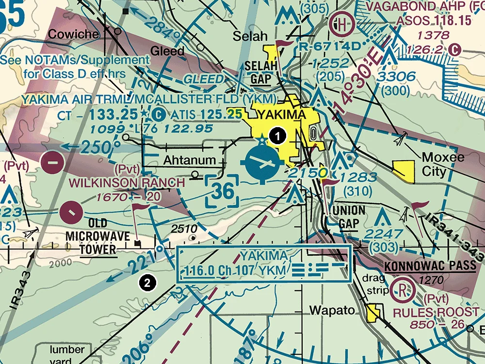
(Refer to the figure, area 1.) What is the ceiling of the Class D airspace at Yakima Air Trml/McAllister Fld (YKM)?
Answer: A. 3,600 feet MSL
3,600 feet MSL. The Class D airspace is outlined by a dashed blue line, and the number in the dashed blue box, 36, is its ceiling in hundreds of feet MSL. Altitudes of charted airspace are MSL, so reading it as 3,600 feet AGL is wrong: that would put the top about 1,099 feet higher, the field elevation. 2,500 feet MSL is the ceiling minus the field elevation, which is roughly the height of the airspace above the airport, not an MSL altitude.
Source
3600
TI
Class D Airspace Altitude in hundreds of feet MSL
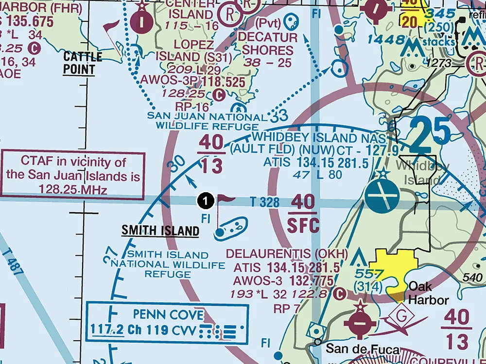
(Refer to the figure, area 1.) What is the ceiling of the Class C airspace above area 1?
Answer: C. 4,000 feet MSL
4,000 feet MSL. Area 1 lies in the Class C sector labeled 40 over 13. In these solid magenta labels the top number is the ceiling and the bottom number the floor, both in hundreds of feet MSL with the last two zeros left off, so this sector spans 1,300 to 4,000 feet MSL. The ceiling is MSL, not AGL, and 1,300 feet MSL is the floor of this sector, where the Class C airspace begins.
Source
4000
MSL
The MSL ceiling and floor altitudes of each sector are shown in solid magenta figures with the last two zeros eliminated.
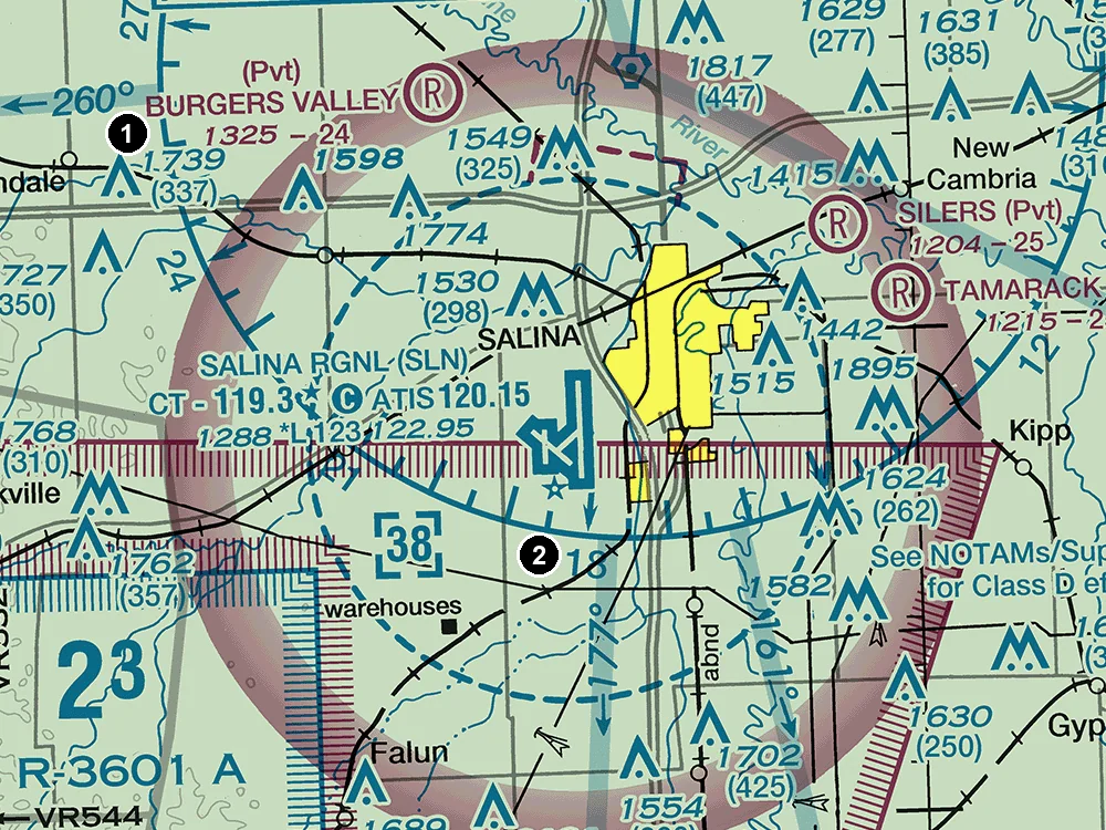
(Refer to the figure, area 2.) A remote pilot plans an early-morning flight near Salina Rgnl (SLN) before its control tower opens. Which frequency should be monitored as the CTAF?
Answer: B. 119.3 MHz
119.3 MHz. The airport is printed in blue, so it has a control tower, and 'CT - 119.3' gives the tower's primary frequency. The star after it means the tower operates part-time, and the circled C means the same frequency is the Common Traffic Advisory Frequency when the tower is closed. 120.15 is the ATIS frequency (recorded airport information); 122.95 is UNICOM, used for services such as fuel requests, so neither is the CTAF.
Source
119.3
Star indicates operation part-time.
Follows the Common Traffic Advisory Frequency (CTAF)
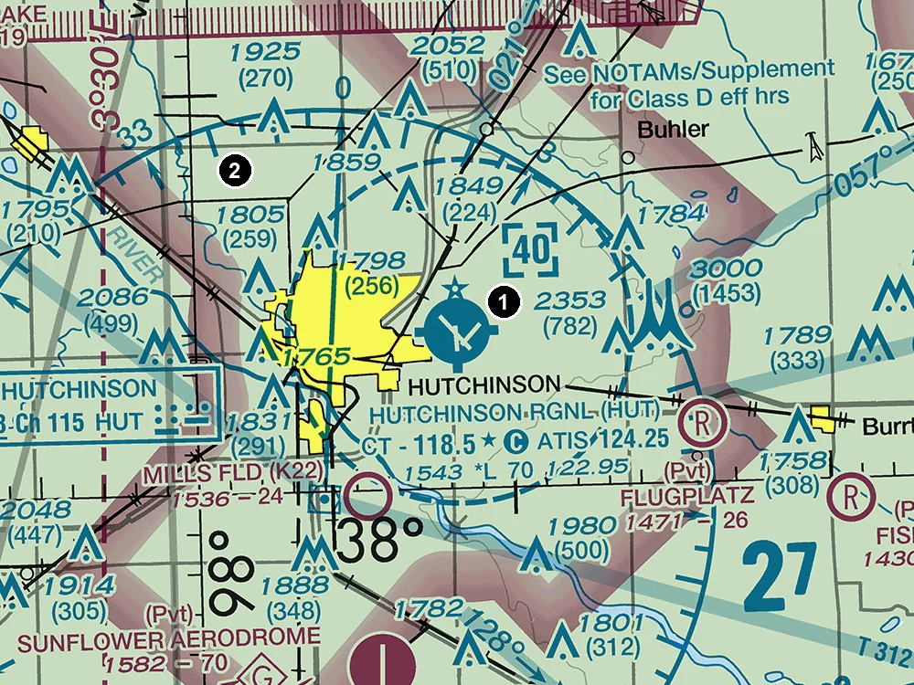
(Refer to the figure, area 1.) What is the ceiling of the Class D airspace at Hutchinson Rgnl (HUT)?
Answer: C. 4,000 feet MSL
4,000 feet MSL. The Class D airspace is outlined by a dashed blue line, and the number in the dashed blue box, 40, is its ceiling in hundreds of feet MSL. Altitudes of charted airspace are MSL, so reading it as 4,000 feet AGL is wrong: that would put the top about 1,543 feet higher, the field elevation. 2,500 feet MSL is the ceiling minus the field elevation, which is roughly the height of the airspace above the airport, not an MSL altitude.
Source
4000
TI
Class D Airspace Altitude in hundreds of feet MSL
(Refer to the figure, area 2.) What is the floor of the Class E airspace at area 2?
Answer: B. 700 feet AGL
700 feet AGL. Area 2 lies inside the fuzzy magenta bands (vignettes) around Hutchinson: the nearest band, just south-west of area 2, has its sharp edge on the far side and fades toward area 2 and the airport. On the faded side of a magenta vignette, Class E airspace begins at 700 feet AGL, with Class G below. Area 2 is outside the dashed lines around the airport, so the floor is not the surface, and 1,200 feet AGL applies only beyond the vignette's sharp outer edge. A small UA flying below 400 feet AGL there stays in Class G airspace.
Source
700
SFC
Controlled airspace floors of 700' above the ground are defined by a magenta vignette
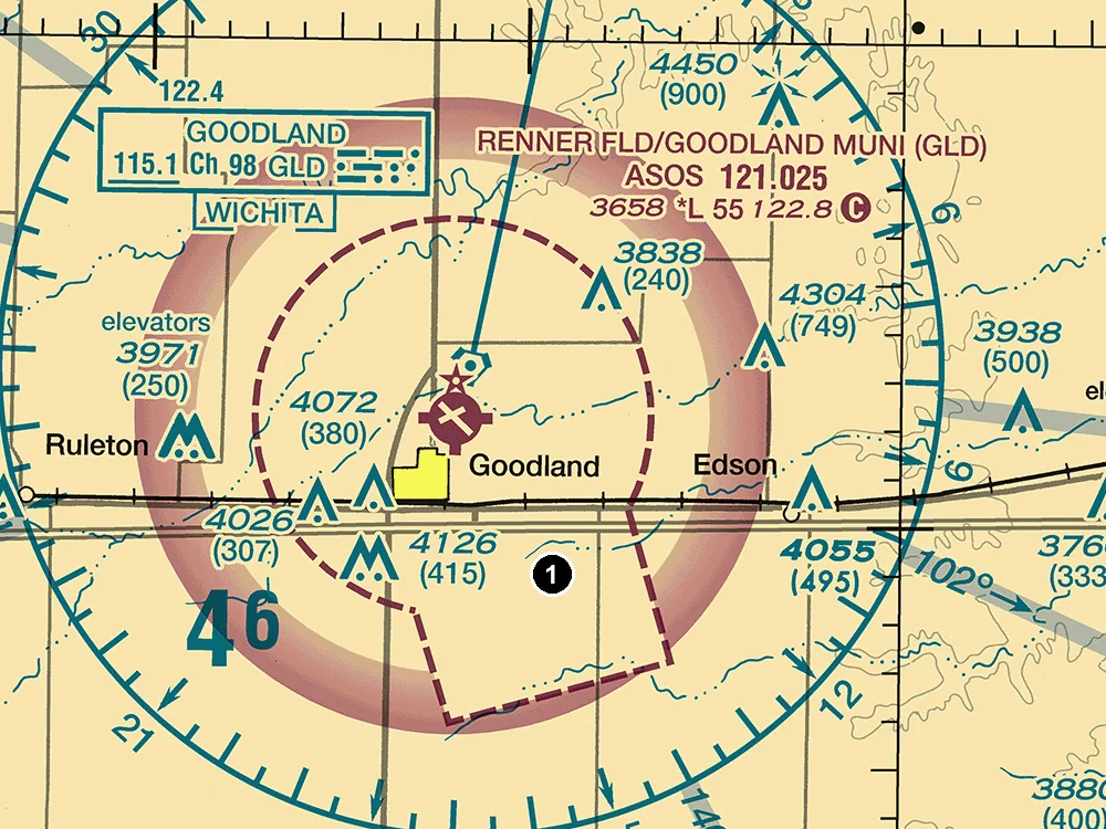
(Refer to the figure, area 1.) A remote pilot plans to fly a small UA at 200 feet AGL at area 1. Assume any control tower in the figure is operating. Is ATC authorization required?
Answer: B. Yes; area 1 is within the lateral boundaries of a Class E surface area (dashed magenta line).
Yes. Area 1 is within the lateral boundaries of a Class E surface area (dashed magenta line). Under 14 CFR 107.41 a small UA may not operate in Class B, C, or D airspace or within the lateral boundaries of a Class E surface area without prior ATC authorization, which a remote pilot normally gets through LAANC or FAA DroneZone. The altitude does not matter: this airspace starts at the ground, so even a 200-foot flight is inside it, and the 400-foot limit of 107.51 does not replace the authorization requirement.
Source
CLASS_E2
SFC
No person may operate a small unmanned aircraft in Class B, Class C, or Class D airspace or within the lateral boundaries of the surface area of Class E airspace designated for an airport
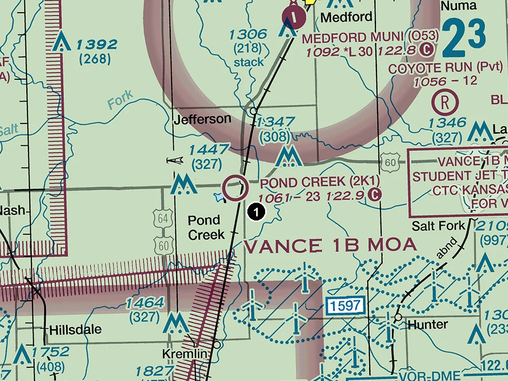
(Refer to the figure, area 1.) A remote pilot will fly near Pond Creek Muni (2K1) and wants to monitor local traffic. Which frequency is the CTAF for this airport?
Answer: B. 122.9 MHz
122.9 MHz. Pond Creek Muni is printed in magenta, so it has no control tower. In its data block the frequency followed by the circled C symbol is the Common Traffic Advisory Frequency, where pilots announce their positions. The Remote Pilot Study Guide advises monitoring the tower frequency or CTAF to get a good idea of what traffic to expect. Neither 122.7 nor 123.0 appears in this airport's data block, so neither is its CTAF.
Source
122.9
Follows the Common Traffic Advisory Frequency (CTAF)
A CTAF is a frequency designated for the purpose of carrying out airport advisory practices while operating to or from an airport without an operating control tower.
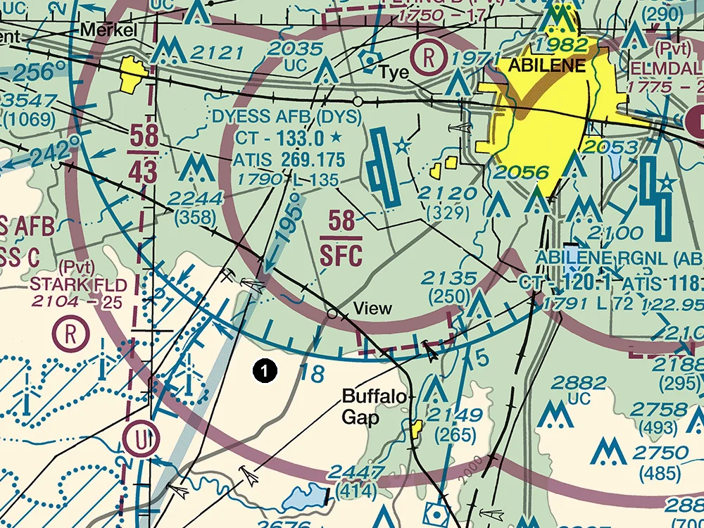
(Refer to the figure, area 1.) A remote pilot plans to fly a small UA at 200 feet AGL at area 1. Assume any control tower in the figure is operating. Is ATC authorization required?
Answer: A. No; area 1 is beneath the Class C shelf, which begins at 4,300 feet MSL there.
No. Area 1 is under the Class C sector labeled 58/43, which begins at 4,300 feet MSL. The ground there is about 2,310 feet MSL, so a flight at 200 feet AGL stays far below that floor, outside the Class C airspace, and no dashed Class D or Class E surface-area line surrounds the area. Under 14 CFR 107.41, ATC authorization is needed only in Class B, C, or D airspace or within the lateral boundaries of a Class E surface area. Being near an airport, under a shelf, or inside a Mode C veil does not by itself require authorization.
Source
4300
700
No person may operate a small unmanned aircraft in Class B, Class C, or Class D airspace or within the lateral boundaries of the surface area of Class E airspace designated for an airport
For pilots who already have a study routine.
$19one-time
Recommended
Build a routine, fix weak areas and rehearse the exam.
$39one-time
Add a printable reference for your final revision.
$59one-time
Already purchased? Restore or manage your access. Access lasts while this site operates.
Help us improve Part 107 HQ with page visits and feature-use counts. Your answers, scores, email and access code stay out of analytics. Privacy policy