Question Bank
For pilots who already have a study routine.
$19one-time
- All 765 practice questions
- Full explanations & official sources
- All 64 current-chart questions
- Topic drills & missed-question review
Weather questions come in two kinds: reading aviation weather reports and forecasts, mainly METARs and TAFs, and understanding how weather affects a small unmanned aircraft — density altitude, atmospheric stability, fronts, fog, thunderstorms, wind shear and icing.
5% of the test. That is the FAA weighting for this area since September 29, 2025 — about 3 of the 60 scored questions.
The explanations walk through each part of a report, so you learn to decode it yourself instead of recognizing one familiar answer.
26 of the 96 questions in this area are free to read here. Try to answer before you open the explanation.
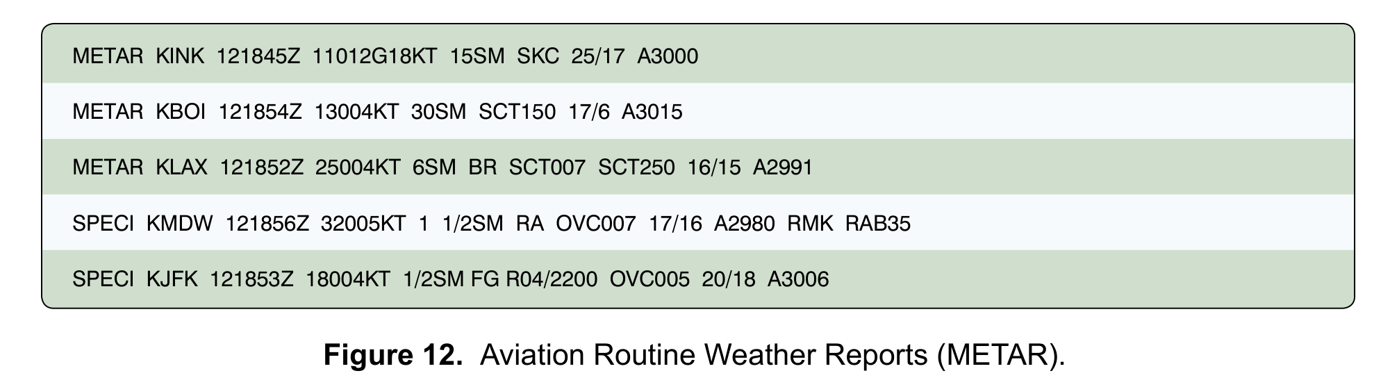
(Refer to FAA-CT-8080-2H, Figure 12.) Considering only the reported visibility, at which airport would conditions prevent a Part 107 flight if the same visibility existed at your control station?
Answer: C. Chicago Midway (KMDW)
Under 14 CFR 107.51(c), flight visibility observed from the control station must be at least 3 statute miles. The KMDW SPECI reports 1 1/2SM: a whole number, a space, and a fraction, so the visibility is one and one-half statute miles, below the minimum. KBOI reports 30SM and KLAX reports 6SM, both well above 3 statute miles, even though KLAX also reports mist (BR). Do not read 1 1/2SM as 11 or 12 miles; the space separates the whole number from the fraction. A METAR describes conditions at the airport, so always confirm the actual visibility at your own control station before you fly.
Source
The minimum flight visibility, as observed from the location of the control station must be no less than 3 statute miles.
The visibility group is coded as the surface visibility in statute miles. A space is coded between whole numbers and fractions of reportable visibility values.
A remote pilot checks this report before an afternoon flight: METAR KFSD 211753Z AUTO 18012KT 10SM CLR 24/12 A3001 RMK AO2. When was the observation taken?
Answer: B. On the 21st day of the month at 1753 UTC.
The date/time group 211753Z reads as day of the month (21), hour (17), and minutes (53). The trailing Z stands for Zulu time, which is Coordinated Universal Time (UTC), so the observation was taken on the 21st at 1753 UTC. Treating 1753 as local time ignores the Z: METAR times are always UTC, so convert them before comparing a report with a local flight schedule. Reading the group as the 17th at 2153 UTC swaps the fields; the day of the month always comes first, followed by the hour and the minutes. (Aviation Weather Handbook, 24.4.3.3, p. 24-9)
Source
the day of the month is the first two digits (01), followed by the hour (19), and the minutes (55).
The date and time group always ends with a Z, indicating Zulu time (or Coordinated Universal Time (UTC)).
METAR KDEN 121653Z 34010KT 10SM FEW020 SCT045 BKN080 OVC150 08/M03 A3012. What is the ceiling?
Answer: B. 8,000 feet AGL, the lowest broken layer.
Sky condition is listed in ascending order: few clouds at 2,000 feet, scattered at 4,500 feet, broken at 8,000 feet, and overcast at 15,000 feet, all above ground level because each three-digit height is in hundreds of feet AGL. The ceiling is the lowest layer aloft reported as broken or overcast, so it is the BKN080 layer at 8,000 feet. The FEW020 layer is the lowest cloud, but few (up to 2/8 of the sky) and scattered (3/8 to 4/8) layers never form a ceiling. Overcast is not required; a broken layer (5/8 to 7/8) already counts, so the OVC150 layer lies above the ceiling. (Aviation Weather Handbook, 24.4.3.9, pp. 24-15 to 24-16)
Source
The ceiling is the lowest layer aloft reported as broken or overcast.
The height of the layer is recorded in feet AGL.
You plan to fly a small UA beside an airport reporting: METAR KBTV 060954Z 18006KT 6SM BR OVC008 06/05 A2996 RMK AO2. If the cloud base over your site matches the report, what is the highest altitude at which the UA would stay at least 500 feet below the clouds?
Answer: A. 300 feet AGL.
OVC008 is an overcast layer with its base at 800 feet AGL (three digits in hundreds of feet above the surface). AC 107-2A requires the small UA to stay at least 500 feet below clouds, so subtracting 500 feet from the 800-foot base leaves 300 feet AGL as the highest usable altitude. 400 feet AGL is the general Part 107 altitude limit, but there the UA would be only 400 feet below the clouds. 1,300 feet AGL adds the 500 feet instead of subtracting it and would put the UA above the clouds, which is not allowed. The 6SM visibility in mist (BR) meets the 3-statute-mile minimum, so the cloud base is the limiting factor here. (Aviation Weather Handbook, 24.4.3.9, p. 24-15; AC 107-2A, 5.12.3, p. 5-12)
Source
The height of the layer is recorded in feet AGL.
the small unmanned aircraft maintains at least 500 feet below clouds and at least 2,000 feet horizontally from clouds.
The small unmanned aircraft cannot be operated above any cloud
METAR KSLC 151756Z AUTO 33008KT 10SM CLR 22/M04 A3010 RMK AO2. What does CLR mean in this report?
Answer: A. No clouds were detected at or below 12,000 feet AGL.
The AUTO modifier and AO2 remark show a fully automated report. Automated stations code CLR when their sensors detect no cloud layers at or below 12,000 feet AGL; clouds above 12,000 feet are not detected or reported by an automated station, so higher clouds may still be present. SKC, used at manual stations, is the code for a human observer seeing no layers at all, so the no-clouds-anywhere reading is wrong. The 12,000-foot limit is a height above ground level, like every METAR cloud height, not MSL. (Aviation Weather Handbook, 24.4.3.9, pp. 24-16 to 24-17; Remote Pilot Study Guide, p. 17)
Source
CLR No layers are detected at or below 12,000 ft AGL.
When SKC is used, an observer indicates no layers are present; CLR is used by automated stations to indicate no layers are detected at or below 12,000 ft.
Clouds above 12,000 feet are not detected or reported by an automated station.
METAR KMSN 090853Z 29008KT 10SM FEW035 M02/M08 A3012 RMK AO2 SLP201. What is the altimeter setting?
Answer: B. 30.12 inches of mercury.
The altimeter group always begins with A, followed by four digits giving inches of mercury to the hundredth with the decimal point left out, so A3012 is 30.12 inches of mercury. Reading it as 1,012 millibars applies the wrong unit; U.S. METARs code the altimeter setting in inches of mercury. The value 1,020.1 millibars comes from the remark SLP201, which is the sea level pressure in millibars with the leading 10 omitted, not the altimeter setting. (Aviation Weather Handbook, 24.4.3.11, p. 24-18; 24.4.3.13.22, p. 24-24)
Source
The altimeter group always starts with an A and is followed by the four-digit group representing the pressure in tens, units, tenths, and hundredths of inches of mercury.
the identifier SLP, immediately followed by the sea level pressure in millibars.
TAF KBOI 121130Z 1212/1312 32010KT P6SM SCT050 TEMPO 1220/1223 2SM -SHRA BKN008. You plan a Part 107 flight from 2030Z to 2100Z on the 12th. What does the TAF indicate about visibility during your flight?
Answer: C. Temporary periods of 2 statute miles in light rain showers, below the 3-mile minimum.
The prevailing forecast is P6SM with scattered clouds at 5,000 feet, but TEMPO 1220/1223 covers the 12th from 2000Z to 2300Z, which includes your flight. TEMPO describes temporary fluctuations to the forecast conditions that have a high (greater than 50 percent) probability of occurring. During them the forecast is 2SM -SHRA BKN008: 2 statute miles in light rain showers with an 800-foot ceiling, below the Part 107 visibility minimum of 3 statute miles. A 30 percent chance describes PROB30, not TEMPO. The TEMPO times bound when the fluctuations occur; after 2300Z the prevailing conditions apply again. (Aviation Weather Handbook, 27.4.2.10.2, p. 27-16; AC 107-2A, 5.12.3, p. 5-12)
Source
The change-indicator group TEMPO YYGG/YeYeGeGe is used to indicate temporary fluctuations to forecast meteorological conditions
Have a high percentage (greater than 50 percent) probability of occurrence;
The remote PIC must determine that the visibility from the CS is at least 3 sm
Which pilot report meets the criteria for an urgent PIREP (UUA)?
Answer: B. Hail encountered at 3,000 feet MSL.
PIREPs are either routine (UA) or urgent (UUA). Urgent PIREPs contain information about tornadoes, funnel clouds, and waterspouts; severe or extreme turbulence; severe icing; hail; low-level wind shear within 2,000 feet of the surface; volcanic ash; and other phenomena the receiving controller or Flight Service specialist considers hazardous. Hail is on that list. Light turbulence and a cloud-top report contain none of the urgent items, so they are distributed as routine UA reports, although they are still useful for planning. Pilots are encouraged to report good weather as well as bad. (Aviation Weather Handbook, 24.5.1 and 24.5.1.1, pp. 24-26 to 24-27)
Source
Urgent (UUA) PIREPs contain information about: • Tornadoes, funnel clouds, and waterspouts; • Severe or extreme turbulence (including CAT); • Severe icing; • Hail;
Routine (UA) PIREPs are issued after receiving a report from a pilot that does not contain any urgent information as listed in Section 24.5.1.1.1.
Pilots can report any observation, good or bad, to assist other pilots with flight planning and preparation.
A PIREP reads: ICT UA /OV ICT270010/TM 1620/FL055/TP C172/SK BKN025-TOP045/TA 08. The terrain at the reported position is about 1,300 feet MSL. About how high above the ground is the base of the broken layer?
Answer: A. About 1,200 feet AGL.
Unlike METAR and TAF cloud heights, which are AGL, PIREP altitudes are MSL unless otherwise noted. In /SK BKN025-TOP045, the base of the broken layer is 2,500 feet MSL and its top is 4,500 feet MSL. Subtracting the 1,300-foot terrain elevation leaves a base about 1,200 feet above the ground. Taking 2,500 feet as AGL ignores the MSL convention, and 3,800 feet comes from adding the terrain elevation instead of subtracting it. The other elements: 10 NM from ICT on the 270° radial, at 1620 UTC, reported from 5,500 feet MSL by a Cessna 172, outside air temperature 8 °C. (Aviation Weather Handbook, 24.5.1, pp. 24-26 to 24-28)
Source
All altitude references are mean sea level unless otherwise noted.
The height of base of a layer of clouds is coded in hundreds of feet MSL. The top of a layer is entered in hundreds of feet MSL preceded by the word TOP.
The altitude/flight level (/FL) is the altitude in hundreds of feet MSL where the phenomenon was first encountered.
A PIREP includes the group /WV 31025KT. How should this wind be read?
Answer: A. From 310° magnetic at 25 knots.
In a PIREP, the /WV element reports the wind the pilot observed aloft: three digits of direction referenced to magnetic north, then the speed in knots. So /WV 31025KT is a wind from 310° magnetic at 25 knots. This differs from METARs and TAFs, whose wind directions are referenced to true north, so reading it as true is a common mix-up. Wind is named for the direction from which it blows, so the toward reading is wrong. The altitude of this wind is the /FL value, given in hundreds of feet MSL. (Aviation Weather Handbook, 24.5.1.9, p. 24-30; 10.2, p. 10-2; AIM TBL 7-1-8)
Source
Wind direction and speed are encoded using three digits to indicate wind direction, relative to magnetic north, and two or three digits to indicate reported wind speed.
Direction in degrees magnetic north and speed in knots
Wind is named according to the direction from which it is blowing.
A convective SIGMET reads in part: CONVECTIVE SIGMET 17W VALID UNTIL 2155Z NM FROM 40N ABQ-30E TCS-40W TCS-40N ABQ AREA SEV TS MOV FROM 25030KT. TOPS ABV FL450. Which way are the storms moving?
Answer: A. Toward the east-northeast at 30 knots.
In a convective SIGMET, MOV FROM 25030KT describes the movement of the thunderstorm area: it is moving from 250° at 30 knots, so it is heading toward about 070°, the east-northeast. The handbook decodes its own example the same way, with storms moving from 240° heading to the northeast. Reading the group as movement toward 250° reverses the direction, and it is not a surface wind report. 17W is the 17th convective SIGMET of the day for the western region, and the outlined area is a snapshot that will shift along this movement vector during the valid time. (Aviation Weather Handbook, 26.2.4.2 and 26.2.4.2.4, pp. 26-7 to 26-10)
Source
For additional clarification, the movement "MOV FROM..." within the Convective SIGMET describes the current movement of the SIGMET area or line.
An intensifying area of severe thunderstorms moving from 240° at 45 kt (to the northeast).
During the valid time of the SIGMET, the area/line will move according to the movement vector given in the SIGMET.
Two airports with weather reports are near your rural work site: one 4 miles away in the same valley, and one 12 miles away on the far side of a mountain ridge. Which report should you use to judge visibility and cloud clearance?
Answer: A. The report from the closer airport in the same valley, as most representative of your site.
AC 107-2A says local aviation weather reports are one way to determine the required visibility and cloud clearance, and that when more than one reporting station is near the operating area, the remote PIC should choose the closest one that is most representative of the terrain around the site. The station in the same valley meets both tests; the one across the ridge is farther away and sits in different terrain. A METAR observes conditions at the station, with phenomena 5 to 10 statute miles away coded as in the vicinity, so it does not describe a 25-mile area. If no local reports are available, the flight cannot proceed until visibility and cloud clearance are determined by other reliable means. (AC 107-2A, 5.12.3, p. 5-12; Aviation Weather Handbook, 24.4.3.8.2, p. 24-13)
Source
If there is more than one local aviation reporting station near the operating area, the remote PIC should choose the closest one that is most representative of the terrain surrounding the operating area.
If local aviation weather reports are not available, the remote PIC cannot operate the small unmanned aircraft until he or she is able to determine the required visibility and cloud clearances by other reliable means.
You listen to an airport's ASOS by telephone and also read the airport's latest METAR online. How is the wind direction referenced in each?
Answer: B. Magnetic in the telephone broadcast; true in the online METAR.
ASOS and AWOS wind direction depends on how the observation is disseminated. National network distribution, which includes Flight Service, the internet, and FIS-B, gives the wind direction in true degrees, as in every coded METAR. Local dissemination, such as the radio and telephone broadcasts, gives it in magnetic degrees. The reverse arrangement is therefore wrong, and the shared sensor does not make both sources magnetic. When comparing a telephone or radio broadcast with an online METAR, allow for the difference between magnetic and true north. (Aviation Weather Handbook, 24.3.1.2, p. 24-3; 24.4.3.5, p. 24-10)
Source
National network distribution (e.g., FSS, internet, and FIS-B) of wind direction is in true degrees, while local dissemination (e.g., radio and telephone) is in magnetic degrees.
It is coded in tens of degrees relative to true north using three figures.
A remote pilot who normally flies near sea level takes the same quadcopter to a job site at 7,000 feet MSL on a hot summer afternoon. Compared with flying at home, what should the pilot expect?
Answer: C. Reduced performance, because the less dense air lowers propeller efficiency and lift.
A high elevation on a hot day means a high density altitude. The AIM (para. 7-6-7) states that high density altitude reduces all aircraft performance parameters, including propeller efficiency and rate of climb, and the Aviation Weather Handbook (FAA-H-8083-28B, p. 8-14) adds that the light air reduces both thrust and lift. Expect reduced lift and slower climbs. The idea that thin air improves the climb is backwards, because a decreased rate of climb is one of the listed effects. Density altitude is not limited to runway operations; it governs how any aircraft performs at that location. AC 107-2A (appendix E) tells remote pilots to review the aircraft's performance capabilities, considering density altitude and wind, before flight.
Source
High density altitude reduces all aircraft performance parameters. To the pilot, this means that the normal horsepower output is reduced, propeller efficiency is reduced
It reduces lift because the light air exerts less force on the airfoils.
Review small unmanned aircraft performance capabilities, considering density altitude and wind, to ensure positive control of the small unmanned aircraft can be maintained
On two afternoons at the same field, the temperature and barometric pressure are identical, but the second afternoon is far more humid. How does the extra moisture affect the small unmanned aircraft's performance?
Answer: A. Performance is lower, because moist air is less dense than dry air.
Water vapor is lighter than air, so moist air is lighter than dry air. The Remote Pilot Study Guide (ch. 3b, p. 22) explains that as the water content of the air increases, the air becomes less dense, increasing density altitude and decreasing performance. The claim that water vapor makes air denser reverses this relationship. Saying only temperature and pressure matter is also wrong: humidity is usually a smaller factor than temperature, but the Study Guide notes that it still contributes, and the AIM (para. 7-6-7) says the effects of high temperature and high humidity are cumulative. On a hot, humid day, expect less performance than the temperature alone suggests.
Source
Water vapor is lighter than air; consequently, moist air is lighter than dry air. Therefore, as the water content of the air increases, the air becomes less dense, increasing density altitude and decreasing performance.
The further effects of high temperature and high humidity are cumulative, resulting in an increasing high density altitude condition.
A remote pilot will inspect the roof of a large warehouse while a strong wind blows across it. According to FAA guidance, what mainly determines how intense the turbulence around the building will be?
Answer: A. The size of the building and the speed of the wind.
AC 107-2A (appendix B, para. B.4.1) states that the intensity of the turbulence associated with ground obstructions depends on the size of the obstacle and the primary velocity of the wind. Buildings, trees, and terrain break up the flow of the wind and create gusts that change rapidly in direction and speed, so the remote PIC should be especially vigilant near large buildings. Dew point and barometric pressure describe moisture and air pressure, not the eddies a building creates. Cloud cover and visibility affect what the pilot can see, not how rough the air around the structure will be. Memory tip: the bigger the obstacle and the stronger the wind, the rougher the air.
Source
The intensity of the turbulence associated with ground obstructions depends on the size of the obstacle and the primary velocity of the wind.
In particular, ground topography, trees, and buildings can break up the flow of the wind and create wind gusts that change rapidly in direction and speed.
A remote pilot is filming along an ocean beach on a sunny summer afternoon when the large-scale winds are light. Which local wind should the pilot expect?
Answer: B. An onshore sea breeze blowing from the water toward the land.
During the day, land heats faster than water, so the air over the land becomes warmer, less dense, and rises. Cooler, denser air flows in from over the water to replace it, producing an onshore wind called a sea breeze (PHAK, pp. 12-7 to 12-8). The Aviation Weather Handbook (p. 10-9) notes that sea breezes usually blow on relatively calm, sunny, summer days. The offshore land breeze is the nighttime reversal, when the land cools faster than the water. Land and water do not heat at the same rate, and that difference is exactly why these local winds form. Memory tip: winds are named for the direction they come from, so a sea breeze comes from the sea.
Source
cooler, denser air flowing in from over the water. This causes an onshore wind called a sea breeze.
Sea breezes usually blow on relatively calm, sunny, summer days.
During a climb-out, a small UA inadvertently flies straight through a microburst. In what order is it most likely to meet the wind changes?
Answer: C. A headwind, then a downdraft, then a tailwind.
A microburst is an intense downdraft that spreads out in all directions when it reaches the surface. The Remote Pilot Study Guide (ch. 3b, p. 24) describes an inadvertent encounter: the small UA may first experience a performance-increasing headwind, followed by performance-decreasing downdrafts, followed by a rapidly increasing tailwind, which can result in terrain impact or flight dangerously close to the ground. The AIM (para. 7-1-24) gives the same headwind, downdraft, tailwind sequence. The other sequences do not fit: the core of a microburst is a downdraft, not an updraft, and the tailwind comes last. The Aviation Weather Handbook (p. 22-18) advises treating a sudden airspeed gain near convective weather as a possible sign of a coming airspeed loss.
Source
During an inadvertent microburst encounter, the small UA may first experience a performance-increasing headwind, followed by performance-decreasing downdrafts, followed by a rapidly increasing tailwind.
The aircraft may encounter a headwind (performance increasing) followed by a downdraft and tailwind (both performance decreasing), possibly resulting in terrain impact.
Any rapid or large airspeed increase, particularly near convective weather conditions, should be viewed as a possible indication of a forthcoming airspeed decrease.
On a hot, dry afternoon, a remote pilot sees streaks of rain hanging from a cloud base without reaching the ground, and beneath them a ring of blowing dust on the surface. What should the pilot suspect?
Answer: B. A microburst: a small, intense downdraft spreading out at the surface.
Rain that evaporates before reaching the ground is virga. The Remote Pilot Study Guide (ch. 3b, p. 24) states that microburst activity may be indicated by an intense rain shaft at the surface, but virga at cloud base and a ring of blowing dust is often the only visible clue; the microburst, the most severe type of low-level wind shear, is associated with convective precipitation falling into dry air at cloud base. That is why the evaporating shower is not harmless, and the AIM (para. 7-1-24) notes that microbursts can occur in light rain in benign-appearing virga. An inversion is a stable layer that traps haze and pollutants; it does not create a spreading ring of dust beneath virga.
Source
Microburst activity may be indicated by an intense rain shaft at the surface but virga at cloud base and a ring of blowing dust is often the only visible clue.
The most severe type of low-level wind shear, a microburst, is associated with convective precipitation into dry air at cloud base.
They may be embedded in heavy rain associated with a thunderstorm or in light rain in benign appearing virga.
A thunderstorm is approaching a construction site. Its rain is still about 10 miles away and the local wind is light, so the remote pilot wants to fit in one more flight before the rain arrives. What hazard does this plan overlook?
Answer: A. The gust front can arrive well ahead of the rain and abruptly change the surface wind.
Downdraft air spreading out ahead of a thunderstorm forms a gust front. The PHAK (p. 12-24) states that gust fronts often move far ahead (up to 15 miles) of the associated precipitation and cause a rapid, and sometimes drastic, change in surface wind ahead of an approaching storm; a roll cloud on the leading edge marks an extremely turbulent zone. The AIM (para. 7-1-27) warns against taking off or landing in the face of an approaching thunderstorm because a sudden gust front of low-level turbulence could cause loss of control. Thunderstorm hazards are not confined to the rain area or to the cloud, so both other choices are wrong. If flying around a thunderstorm is not an option, the PHAK advises staying on the ground until it passes.
Source
Gust fronts often move far ahead (up to 15 miles) of associated precipitation. The gust front causes a rapid, and sometimes drastic, change in surface wind ahead of an approaching storm.
Don't land or takeoff in the face of an approaching thunderstorm. A sudden gust front of low level turbulence could cause loss of control.
Which group of weather conditions is typical of an unstable air mass?
Answer: C. Cumuliform clouds, showery precipitation, turbulence, and good visibility.
In unstable air, small vertical air movements tend to become larger, producing turbulent airflow and convective activity (PHAK, p. 12-12). The Remote Pilot Study Guide (ch. 3b, p. 26) lists the characteristics of unstable air as cumuliform clouds, showery precipitation, rough air (turbulence), and good visibility except in blowing obstructions; the PHAK (p. 12-18) likewise says moist, unstable air causes cumulus clouds, showers, and turbulence, with good surface visibility. The other two groups describe stable air: stratiform clouds and fog, continuous precipitation, smooth air, and fair to poor visibility in haze and smoke. Memory tip: unstable air is bumpy but clear; stable air is smooth but murky.
Source
Moist, unstable air causes cumulus clouds, showers, and turbulence to form.
This creates an unstable air mass with good surface visibility.
In an unstable atmosphere, small vertical air movements tend to become larger, resulting in turbulent airflow and convective activity.
A cool air mass moves inland from the ocean over ground that has been strongly heated by the sun. How is the air mass likely to change, and what should a remote pilot expect?
Answer: B. It becomes unstable, with convective turbulence and good surface visibility.
An air mass is modified by the surface it passes over. The PHAK (p. 12-18) explains that an air mass passing over a warmer surface is warmed from below, convective currents form, and the result is an unstable air mass with good surface visibility; if the air is moist, cumulus clouds, showers, and turbulence develop. The stable outcome, with low stratus, fog, and poor surface visibility, happens when an air mass passes over a colder surface, the reverse of this case. The claim that the air mass stays the same ignores that it is subjected to the varying conditions of the land or water it crosses, which modify its nature. Expect a bumpy flight.
Source
An air mass passing over a warmer surface is warmed from below, and convective currents form, causing the air to rise. This creates an unstable air mass with good surface visibility.
the air mass is subjected to the varying conditions of the land or water which modify the nature of the air mass.
Which two conditions are necessary for structural icing to form on an aircraft in flight?
Answer: B. Visible moisture, and 0 °C or colder where it strikes the aircraft.
The Remote Pilot Study Guide (ch. 3b, p. 26) lists two conditions necessary for structural icing in flight: the aircraft must be flying through visible water such as rain or cloud droplets, and the temperature at the point where the moisture strikes the aircraft must be 0 °C or colder. Humidity alone is not enough, because there must be liquid water to freeze, and a temperature below 10 °C may still be well above freezing. Clear air has no droplets at all, and the Aviation Weather Handbook (p. 20-2) notes that below -20 °C, clouds are generally composed entirely of ice crystals. Memory tip: visible moisture plus a freezing surface equals ice.
Source
The aircraft must be flying through visible water such as rain or cloud droplets
The temperature at the point where the moisture strikes the aircraft must be 0° C or colder.
Below -20°C, clouds are generally composed entirely of ice crystals.
After a clear night with almost no wind, a remote pilot arrives at sunrise to find fog lying in the low fields and hollows around the site. Which type of fog is this most likely to be?
Answer: C. Radiation fog.
The PHAK (p. 12-15) states that on clear nights, with relatively little to no wind present, radiation fog may develop, usually in low-lying areas, when the ground cools rapidly and the air reaches its dew point. Advection fog and upslope fog both require wind: advection fog forms when warm, moist air moves over a cold surface, and upslope fog forms when moist, stable air is forced up sloping terrain. Radiation fog lifts and eventually burns off as the sun rises and the temperature increases, and any increase in wind speeds its dissipation. Before launching, wait until visibility from the control station is at least 3 statute miles (AC 107-2A, para. 5.12.3).
Source
On clear nights, with relatively little to no wind present, radiation fog may develop.
As the sun rises and the temperature increases, radiation fog lifts and eventually burns off.
The remote PIC must determine that the visibility from the CS is at least 3 sm
Which type of fog forms when moist, stable air is forced up sloping terrain, such as the slopes of a mountain range?
Answer: B. Upslope fog.
The PHAK (p. 12-15) states that upslope fog occurs when moist, stable air is forced up sloping land features like a mountain range, and that it requires wind for formation and continued existence. Unlike radiation fog, upslope and advection fog may not burn off with the morning sun and can persist for days. Radiation fog forms on clear nights with little or no wind, when the ground cools the air to its dew point, usually in low-lying areas rather than on slopes. Steam fog forms when cold, dry air moves over warm water. The Aviation Weather Handbook (p. 18-6) adds that upslope fog is often quite dense and extends to high altitudes.
Source
Upslope fog occurs when moist, stable air is forced up sloping land features like a mountain range.
Upslope and advection fog, unlike radiation fog, may not burn off with the morning sun but instead can persist for days.
Upslope fog is often quite dense and extends to high altitudes.
Which cloud types are classified as low clouds, the family that most often creates low ceilings and hampers visibility?
Answer: B. Stratus, stratocumulus, and nimbostratus.
The PHAK (p. 12-15) defines low clouds as those that form near the Earth's surface and extend up to about 6,500 feet AGL. Typical low clouds are stratus, stratocumulus, and nimbostratus, and fog is also classified as a low cloud formation. Clouds in this family create low ceilings, hamper visibility, and can change rapidly. Altostratus and altocumulus are middle clouds, forming around 6,500 feet AGL and extending up to 20,000 feet AGL (p. 12-16). Cirrus, cirrostratus, and cirrocumulus are high clouds that form above 20,000 feet AGL and are made of ice crystals. Because small UA fly close to the ground, the low family matters most for cloud clearance.
Source
Typical low clouds are stratus, stratocumulus, and nimbostratus.
Clouds in this family create low ceilings, hamper visibility, and can change rapidly.
Middle clouds form around 6,500 feet AGL and extend up to 20,000 feet AGL.
For pilots who already have a study routine.
$19one-time
Recommended
Build a routine, fix weak areas and rehearse the exam.
$39one-time
Add a printable reference for your final revision.
$59one-time
Already purchased? Restore or manage your access. Access lasts while this site operates.
Help us improve Part 107 HQ with page visits and feature-use counts. Your answers, scores, email and access code stay out of analytics. Privacy policy