Part 107 Airspace Classes and ATC Authorization
By Part 107 HQ · Updated
A Part 107 flight needs prior ATC authorization when it operates in Class B, C or D, or within the lateral boundaries of a Class E surface area designated for an airport. Staying below 400 feet AGL does not remove that requirement (14 CFR 107.41).
Class E beginning at 700 or 1,200 feet AGL is a different case. If Class G lies beneath that floor and no other designation overlaps the location, a flight at 300 feet AGL is in Class G and does not require authorization under § 107.41 solely because Class E is overhead. Check the actual designation, floor and effective times; a closed tower can leave a Class E surface area in effect (AIM 3-2-6e and 3-3-1; § 107.41).
Airspace classification and operating requirements make up 20% of the FAA Remote Pilot knowledge test (PSI UAG bulletin, p. 4).
Controlled airspace is the generic term for Classes A, B, C, D and E; Class G is uncontrolled (AIM 3-2-1, 3-3-1). Where designations overlap, the operating rules of the more restrictive airspace apply (AIM 3-1-3).
For a chart question, work in this order: location → boundary → floor and ceiling → airspace at the proposed altitude → authorization rule. The table gives the main chart clues; the sections below explain exceptions and operating times (Chart Users’ Guide, pp. 16–17, 27).
| Airspace | Main sectional clue | What to check for a Part 107 flight |
|---|---|---|
| Class A | Not depicted on the sectional | Begins at 18,000 feet MSL; see its limits below |
| Class B | Solid blue boundaries and sector figures | MSL floor and ceiling; prior ATC authorization when in Class B |
| Class C | Solid magenta boundaries and sector figures | MSL floor and ceiling; prior ATC authorization when in Class C |
| Class D | Dashed blue boundary and boxed ceiling | Ceiling in hundreds of feet MSL and effective hours; prior ATC authorization when in Class D |
| Class E at the surface | Dashed magenta boundary | Confirm the designation; § 107.41 names the surface area designated for an airport |
| Class E above the surface | Magenta or blue vignette, with floor labels where applicable | A 700- or 1,200-foot AGL floor leaves airspace beneath it to identify |
| Class G | Airspace outside the other designations | No authorization under § 107.41; airport traffic and other restrictions still matter |
The authorization entries follow § 107.41. Use the sectional chart guide for number-reading examples, or begin with the free airspace practice.
Class A
- Generally from 18,000 feet MSL up to and including FL 600 (AIM 3-2-2).
- Not depicted on visual charts such as sectionals (Chart Users’ Guide, p. 16).
Class B
- Generally from the surface to 10,000 feet MSL around the nation’s busiest airports. Each area is individually tailored, with a surface area and two or more layers; some resemble upside-down wedding cakes (AIM 3-2-3).
- On sectionals, each sector’s MSL ceiling and floor appear in solid blue figures with the last two zeros omitted. At and below a floor marked with a plus sign you are outside Class B (Chart Users’ Guide, p. 16).
- Part 107: prior ATC authorization required.
Class C
- Generally from the surface to 4,000 feet above the airport elevation (charted in MSL), around airports that have an operational control tower, are serviced by a radar approach control, and have a certain number of IFR operations or passenger enplanements (AIM 3-2-4).
- Usually a 5 NM radius core from the surface to 4,000 feet above the airport, and a 10 NM radius shelf from no lower than 1,200 feet up to 4,000 feet above the airport (AIM 3-2-4).
- On sectionals, each sector’s MSL ceiling and floor appear in solid magenta figures with the last two zeros omitted. A “T” ceiling means up to, but not including, the floor of the overlying Class B (Chart Users’ Guide, p. 16).
- Part 107: prior ATC authorization required. Below the floor of a shelf you are not in Class C, so check which airspace lies underneath.
Class D
- Generally from the surface to 2,500 feet above the airport elevation (charted in MSL), around airports with an operational control tower; each area is individually tailored (AIM 3-2-5).
- Depicted with blue segmented (dashed) lines (AIM 3-2-5). The ceiling is shown in hundreds of feet MSL; a minus sign means from the surface up to, but not including, that altitude (Chart Users’ Guide, p. 27).
- Part 107: a remote pilot must receive ATC authorization before operating in Class D (Remote Pilot Study Guide, p. 6).
- Part-time towers: when a part-time Class D surface area is not in effect, it reverts to a Class E surface area or to Class G. The airport’s Chart Supplement entry says which, for example “other times CLASS E” (AIM 3-2-5). A Class E surface area is still covered by § 107.41; Class G is not.
Class E
Class E is the controlled airspace that is not Class A, B, C or D (Remote Pilot Study Guide, p. 6). It takes several forms (AIM 3-2-6):
- Surface area designated for an airport, for example where a control tower is not in operation. It starts at the surface and is charted with a magenta dashed line (Chart Users’ Guide, p. 17). This is the form of Class E named in § 107.41, so it needs prior ATC authorization.
- Transition areas starting at 700 feet AGL (magenta vignette) or 1,200 feet AGL (blue vignette) at airports with an approved instrument procedure. They remain in effect regardless of airport operating hours.
- Federal airways, from 1,200 feet AGL up to, but not including, 18,000 feet MSL unless otherwise specified.
- Higher airspace: unless designated lower, Class E generally extends from 14,500 feet MSL to, but not including, 18,000 feet MSL over the contiguous states and Alaska. That general layer excludes the Alaska peninsula west of 160°W and airspace below 1,500 feet above the surface unless specifically designated lower. Airspace above FL 600 is Class E (AIM 3-2-6d).
In most cases a remote pilot will not need ATC authorization to operate in Class E airspace (Remote Pilot Study Guide, p. 6); § 107.41 specifically names the lateral boundaries of the surface area designated for an airport.
Class E diagram: surface, 700 feet and 1,200 feet
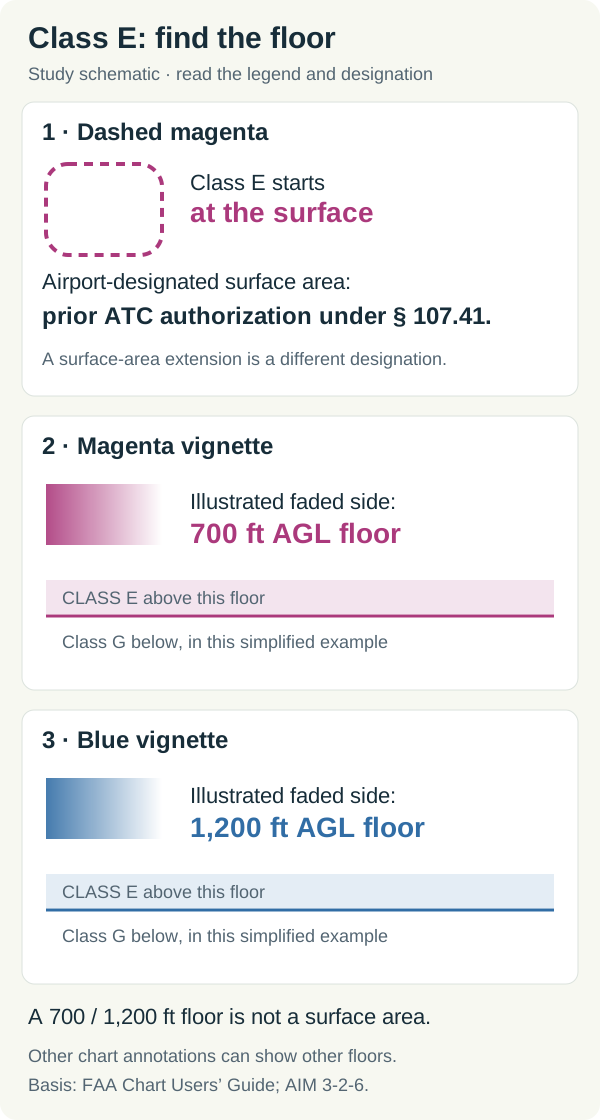
Original teaching diagram, not an actual sectional excerpt. It shows the vertical floors for three selected cases, using the FAA’s chart conventions (Chart Users’ Guide, pp. 17, 27; AIM 3-2-6). Blue vignettes can also mark higher floors where Class E borders Class G; read the chart’s labels.
For a narrated comparison, watch Part 107 Class E: 700 ft AGL vs Surface Airspace. The worked examples below apply those boundaries and floors to planned altitudes.
The dashed magenta case begins at the surface. The shaded cases begin above it. A dashed magenta boundary may also depict a surface-area extension, which the AIM describes separately from a surface area designated for an airport. Confirm the airspace designation and effective times instead of treating every dashed outline as the same authorization case (Chart Users’ Guide, p. 27; AIM 3-2-6e; § 107.41).
Worked example 1: a low flight in an airport surface area
Assume the proposed location is within the lateral boundaries of a Class E surface area designated for an airport, and that area is in effect. The planned altitude is 200 feet AGL. Prior ATC authorization is required under § 107.41. The fact that 200 feet is below the normal 400-foot altitude limit does not remove the authorization requirement.
Worked example 2: a flight below a 700-foot floor
Assume the chart establishes a 700-foot AGL Class E floor at the location, with Class G below it and no other overlapping designation. A drone at 300 feet AGL is in Class G: 300 is below 700. That flight does not require authorization under § 107.41 solely because Class E lies overhead (AIM 3-2-6e3 and 3-3-1; § 107.41). The same reasoning applies to a 300-foot flight where the confirmed Class E floor is 1,200 feet AGL and Class G lies beneath it.
You still assess local restrictions and hazards before flight under § 107.49, and avoid interfering with airport operations under § 107.43.
Worked example 3: below a Class C shelf is only the first answer
For a hypothetical location, a Class C shelf begins at 1,500 feet MSL. The ground directly beneath the drone is 1,000 feet MSL. At 300 feet AGL, the drone would be at 1,000 + 300 = 1,300 feet MSL, below the shelf. Class C sector figures use MSL (Chart Users’ Guide, p. 16).
Next identify what lies below the shelf. If it is Class G, § 107.41 does not require authorization for that class. If it is Class D or an airport-designated Class E surface area in effect, the authorization requirement still applies. This is why reading the outer Class C boundary alone is insufficient (§ 107.41). For more conversions, see the AGL and MSL examples.
Class G
- Class G is the airspace not designated as Class A, B, C, D or E (AIM 3-3-1). It extends from the surface to the base of the overlying Class E (Remote Pilot Study Guide, p. 6).
- Part 107: no ATC authorization needed. Remote pilots may fly in Class G up to 400 feet AGL, and within 400 feet of a structure, without prior coordination with ATC (AIM 11-4-2).
- An airport in Class G can still have a control tower (PHAK, p. 15-11). At any airport, heliport or seaplane base you must not interfere with operations and traffic patterns (14 CFR 107.43).
Weather minimums do not change with the class
Manned VFR visibility and cloud-clearance minimums vary by airspace class (AIM 3-1-4). Part 107 has one set of limits for every class: at least 3 statute miles of flight visibility from the control station, and at least 500 feet below and 2,000 feet horizontally from clouds (14 CFR 107.51).
How to get ATC authorization
- Use LAANC or FAADroneZone. All airspace authorization must be requested through one of these two systems, not by contacting a control tower (FAA UAS FAQ). Small UAS operators should not contact ATC by radio or telephone for airspace access (AIM 11-8-2).
- LAANC, the Low Altitude Authorization and Notification Capability, is an FAA and industry collaboration that automates the application and approval process through apps from FAA-approved UAS service suppliers (AIM 11-8-7). It gives near real-time authorization within UAS Facility Map altitudes (AIM 11-4-2).
- UAS Facility Maps show the maximum altitude at which an operation can be approved without further coordination with the ATC facility. Part 107 pilots may request further coordination above those values, up to 400 feet AGL (AIM 11-1-2). The maps are for information only; they are not an authorization (FAA UAS FAQ).
- FAADroneZone is the FAA’s portal for registering drones and requesting Part 107 airspace authorizations and waivers (AIM 11-8-7). Requests to operate on an airport within controlled airspace must go through DroneZone (AIM 11-7-1).
- What an authorization does not cover. The FAA does not verify that a request is outside § 99.7 security TFRs; Part 107 operators are responsible for staying outside all § 99.7 TFRs and special use airspace. The FAA can also cancel or temporarily suspend an approved operation if conditions change (FAA UAS FAQ).
- Waiver. § 107.41 is on the list of rules that can be waived (14 CFR 107.205).
Near airports where no authorization is needed
Away from the airspace listed in § 107.41, no notification or authorization is needed to fly a small unmanned aircraft at or near an airport. You must still avoid traffic patterns and approach corridors, stay out of any area where you could interfere with airport operations, such as runways, taxiways and helipads, and yield right-of-way to all other aircraft (AC 107-2A, para. 5.10.1).
Free airspace self-check
These original checks assume the designations and operating times stated in each prompt. Open the answer after deciding.
Class E begins at 1,200 feet AGL with Class G beneath it. What class is a drone in at 400 feet AGL?
Class G, assuming no other designation overlaps the location. The 1,200-foot floor is measured above ground, so the proposed altitude is beneath it. See AIM 3-2-6e3 and 3-3-1.
A flight is within an airport-designated Class E surface area in effect, at 200 feet AGL. Is prior authorization required?
Yes. The location is within the lateral boundaries named by § 107.41. A flight below 400 feet AGL must still meet that rule.
A part-time tower is closed. Can the pilot assume the airport's surface airspace is Class G?
No. A part-time Class D surface area can revert to Class E or Class G. Read the Chart Supplement’s airspace entry and effective times (AIM 3-2-5). Monitoring CTAF does not establish an airspace authorization.
Practice the decision with the free airspace questions, then apply it to dated pictures in the sectional chart questions. For flights near airports, continue with CTAF and UNICOM frequencies and airport traffic patterns; the 2026 test-change guide explains how chart images fit the exam.