CTAF vs UNICOM: Airport Frequencies for Part 107
By Part 107 HQ · Updated
CTAF is the frequency designated for airport traffic advisories; UNICOM is a nongovernment radio station that may provide airport information. A UNICOM frequency can also be the CTAF, but that designation must be published. An airport can list a UNICOM frequency and a different CTAF (AIM 4-1-9(b)(1) and (e), pp. 4-1-3 and 4-1-5).
When a chart question asks which frequency to monitor for traffic while a tower is closed, find the published CTAF. On a sectional, a circled C follows that frequency; a star marks a part-time tower. Use the frequency attached to the CTAF symbol rather than assuming the separate UNICOM or weather frequency is the answer (Chart Users’ Guide, p. 15). The dated CSM excerpt below shows all three labels together.
What each frequency does
| Label | Meaning | What to look for |
|---|---|---|
| CTAF | Common Traffic Advisory Frequency, used for airport advisory practices when there is no operating control tower | The published CTAF; on a sectional, the circled C follows its frequency |
| UNICOM | A nongovernment air/ground station that may provide airport information | A separately listed advisory frequency, which may also be designated CTAF |
| CT | Control tower’s primary frequency | A star beside the tower frequency indicates part-time operation |
| ASOS/AWOS | Automated weather observation broadcast | A weather label; this is a different purpose from traffic position reports |
The first two definitions come from AIM 4-1-9. The chart markings and weather labels are explained in the FAA Chart Users’ Guide, p. 15.
A CTAF may be a UNICOM, MULTICOM, Flight Service Station, or tower frequency. When a part-time tower is closed and there is no open FSS on the airport, pilots use the published CTAF for self-announcements. For an airport with no tower, FSS, or UNICOM, the AIM specifies MULTICOM 122.9 MHz; identify the airport’s published arrangement rather than treating that number as a universal CTAF (AIM 4-1-9(b)(1) and (g)(2)–(3), pp. 4-1-3 and 4-1-6).
Find the circled C on the chart
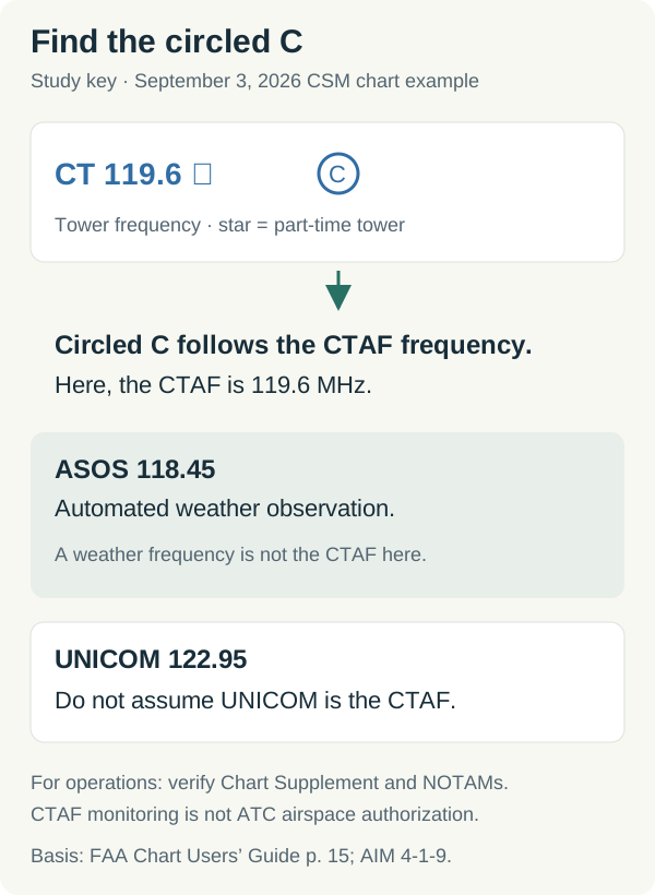
Original schematic based on the FAA Chart Users’ Guide, p. 15. Educational illustration, not for navigation or an airport briefing.
The circled C belongs to the frequency immediately before it. The star answers a separate question: whether the tower operates part-time. Check published operating hours before making assumptions about the tower’s status. A tower closure also does not by itself settle the airspace-authorization question; consult the airport’s published airspace information and Part 107 airspace rules.
Here is a real FAA chart excerpt used in our free practice:
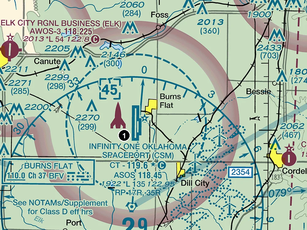
FAA Dallas-Ft Worth Sectional, September 3, 2026 edition, area 1: Infinity One Oklahoma Spaceport (CSM). The numbered marker was added for practice. Source: FAA VFR raster charts. This dated practice image illustrates chart reading; use current publications for an actual operation.
Read CSM’s data block one line at a time: CT 119.6 has the star and circled C; ASOS 118.45 identifies weather; 122.95 on the airport-data line is UNICOM. The circled C identifies 119.6 MHz as CTAF in this example (Chart Users’ Guide, p. 15).
For a narrated walkthrough, watch Part 107 CTAF vs UNICOM: Read the Circled C, then try the free chart check below.
What a remote pilot should do with this information
The FAA encourages small UAS operators to monitor local CTAF traffic near an airport for situational awareness. Airspace authorizations are handled through the airspace-access processes, such as LAANC or DroneZone; they are not arranged through an improvised radio conversation. The AIM tells small UAS operators not to contact ATC directly by radio or telephone for airspace access (AIM 11-8-2 and Notes 1–2, p. 11-8-1).
Listening helps you interpret calls such as “downwind,” “base,” and “final”; our airport traffic pattern guide maps those positions. Keep looking for aircraft. Some aircraft have no radio, and some pilots do not announce their position. Nearby airports may also share a frequency, so listen for the airport name (AIM 4-1-9(a)(1) and (g)(8), pp. 4-1-2 and 4-1-6).
Check your understanding
1. Read the FAA chart
This is an existing free practice question. Refer to area 1 in the chart above: a remote pilot plans an early-morning flight near CSM before its control tower opens. Which frequency should be monitored as the CTAF?
- 119.6 MHz
- 118.45 MHz
- 122.95 MHz
Show answer and reasoning
119.6 MHz. The circled C follows the tower frequency, identifying it as CTAF. The star indicates part-time tower operation. ASOS 118.45 provides automated weather; 122.95 is the separate UNICOM listing. These symbols are defined in the FAA Chart Users’ Guide, p. 15.
2. Can UNICOM also be CTAF?
A fictional airport’s Chart Supplement lists “CTAF 122.8” and “UNICOM 122.8.” Do those matching numbers contradict the definitions?
Show answer and reasoning
No. The same frequency can serve both purposes when UNICOM is designated as CTAF. The published designation resolves the question; “UNICOM” alone does not establish that every airport uses it for CTAF (AIM 4-1-9(e)(2)).
3. Is a quiet CTAF permission to launch?
A remote pilot hears no calls for several minutes. Does that establish that a planned flight near the airport is clear of traffic and authorized?
Show answer and reasoning
No. Radio silence does not establish the absence of aircraft. The drone must yield and remain well clear under § 107.37, must not interfere with airport operations under § 107.43, and needs prior ATC authorization where § 107.41 applies.
Continue with free operations practice for radio and airport procedures, or sectional chart questions to apply the symbols. For the surrounding airport-data block, see how to read a sectional chart.