Airport Traffic Patterns for Part 107
By Part 107 HQ · Updated
An airport traffic pattern organizes aircraft arriving at and departing from a runway. Recognizing its legs helps a remote pilot understand radio calls and locate potential traffic. Under Part 107, the drone must yield to other aircraft and must not interfere with operations or traffic patterns at an airport, heliport, or seaplane base (14 CFR 107.37; 107.43).
Use the diagram to identify where crewed aircraft may be. The FAA advises remote pilots to avoid traffic patterns and published approach corridors; these are aircraft paths to protect when planning a drone operation (AC 107-2A, § 5.10.1–5.10.1.2, pp. 5-7–5-8).
Read the runway number first
Runway numbers indicate the runway centerline’s approximate magnetic direction of approach, expressed in tens of degrees. Runway 09 therefore indicates approximately 090° magnetic, toward the east; Runway 27 indicates approximately 270° magnetic, toward the west. The numbering is rounded, so a runway’s actual magnetic direction need not equal the number multiplied by ten (PHAK, Chapter 14, p. 14-8; AIM 4-3-6(a), p. 4-3-9).
For parallel runways, L, C, and R mean left, center, and right as viewed from the approach direction. A runway named 09R does not itself specify right turns in its traffic pattern. Turn direction is a separate piece of information (PHAK, p. 14-8).
The traffic pattern legs
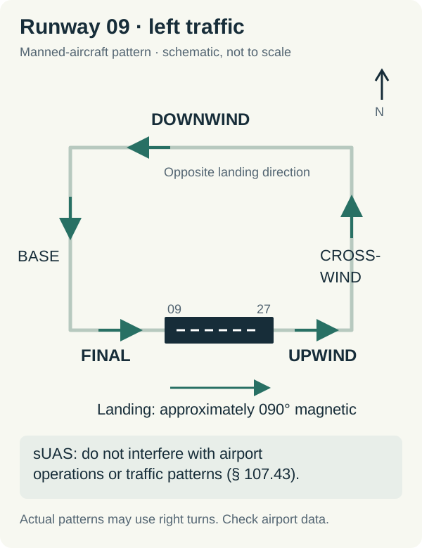
Original schematic: Runway 09 is drawn with east to the right and north at the top. It shows terminology and relative directions, not scale, pattern entry instructions, or a route for a drone. Not for navigation.
| Leg | Position relative to the runway | Direction in this Runway 09 example |
|---|---|---|
| Departure | Begins after takeoff along the extended runway centerline | East |
| Upwind | Continues straight ahead beyond departure along the extended centerline | East |
| Crosswind | At right angles to the runway beyond its takeoff end | North |
| Downwind | Parallel to the runway, opposite the landing direction | West |
| Base | At right angles beyond the approach end, joining the extended centerline | South |
| Final | Along the extended centerline toward the runway, in the landing direction | East |
These definitions follow AIM 4-3-2(c), p. 4-3-2. Downwind means opposite the direction of landing, not a fixed compass direction. Change the landing direction and you change the directions of the pattern legs.
For example, a call of “left downwind, Runway 09” places the aircraft approximately westbound on the north side in this simplified layout. “Left base, Runway 09” places it southbound before its turn toward an eastbound final. Interpret the runway and leg together, then use visual observation to establish the aircraft’s actual location.
Left traffic, right traffic, and exceptions
Unless otherwise indicated, pattern turns are to the left, with helicopter exceptions as applicable. “Left” describes the aircraft’s turns. For the eastbound landing direction shown above, a left pattern lies north of the runway. It does not mean the left side of the page (AIM 4-3-3(c), p. 4-3-4).
On sectional charts, RP followed by runway numbers indicates right traffic for those runways at public-use and joint-use airports. *RP refers to special conditions in the Chart Supplement. Right patterns are not shown for airports with full-time control towers, where instructions may determine the traffic flow (AIM 4-3-2(b) and 4-3-3(d), pp. 4-3-1 and 4-3-4).
Helicopters can use a lower, closer pattern, and in some circumstances the opposite side of the runway if local policy permits. Aircraft may also approach straight in. The rectangle is a terminology aid, not a complete picture of every possible arrival (AIM 4-3-3(a)(3) and (d), pp. 4-3-3–4-3-4).
Pattern altitude does not create a safe layer for drones
The AIM recommends 1,000 feet AGL for propeller-driven aircraft, unless another pattern altitude is published or cloud-clearance requirements dictate otherwise. Large and turbine-powered aircraft use at least 1,500 feet AGL or 500 feet above the established pattern altitude. Check the Chart Supplement for the airport’s published information (AIM 4-3-3(a), p. 4-3-3).
Do not infer that staying below 400 feet AGL keeps a drone clear of aircraft. Aircraft descend on final and climb after departure; the FAA also explicitly notes that crewed aircraft, including helicopters and agricultural aircraft, may fly below 400 feet AGL (AIM 11-8-3(b)(1), p. 11-8-1). Plan to keep the drone well clear and avoid interfering with the airport’s operations.
Check your understanding
1. Which way is downwind?
In the diagram, an airplane announces “left downwind, Runway 09.” Is it traveling east or west, and on which side of the runway?
Show answer and reasoning
West, on the north side in this diagram. Landing on Runway 09 is eastbound. Downwind runs parallel in the opposite direction, and the depicted left turns place the rectangular pattern north of the runway (AIM 4-3-2(c)(4) and 4-3-3(c)).
2. What does RP 09 mean?
A fictional public-use airport’s sectional data block includes “RP 09.” Should you use the left-pattern diagram above to predict its Runway 09 traffic?
Show answer and reasoning
RP 09 indicates right traffic for Runway 09. A simplified right pattern would mirror the illustrated left pattern across the runway. Consult the Chart Supplement and actual conditions rather than assuming the left-pattern picture applies (AIM 4-3-3(d)).
3. Is avoiding an immediate collision enough?
A proposed drone photo hover above a runway would make an airplane delay departure, even though the drone is not immediately close to that airplane. Does that satisfy Part 107?
Show answer and reasoning
No. Interfering with airport operations violates § 107.43 even without an immediate collision hazard. AC 107-2A § 5.10.1.1, p. 5-8, explains this distinction using a drone hover above a runway that delays takeoff or landing.
Try free operations practice for airport and radio questions. Pair this guide with CTAF vs UNICOM to understand the calls you hear, and Part 107 airspace classes to evaluate the separate authorization requirement.